Garmin dezl Owners Manual - Page 9
Driver Awareness Features and Alerts, Navigating to Your Destination
 |
View all Garmin dezl manuals
Add to My Manuals
Save this manual to your list of manuals |
Page 9 highlights
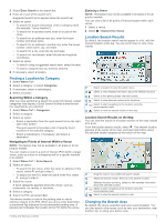
Driver Awareness Features and Alerts NOTICE The driver alerts and speed limit features are for information only and do not replace your responsibility to abide by all posted speed limit signs and to use safe driving judgment at all times. Garmin® is not responsible for any traffic fines or citations you receive for failing to follow all applicable traffic laws and signs. Your device provides features that can help encourage safer driving and increase efficiency, even when you are driving in a familiar area. The device plays an audible tone or message and displays information for each alert. You can enable or disable the audible tone for some types of driver alerts. Not all alerts are available in all areas. Schools: The device plays a tone and displays the distance to and speed limit (if available) for an upcoming school or school zone. Speed limit reduction: The device plays a tone and displays the upcoming reduced speed limit so you can be prepared to reduce your speed. Speed limit exceeded: The device plays a tone and displays a red border on the speed limit icon when you exceed the posted speed limit for the current road. Speed limit change: The device plays a tone and displays the upcoming speed limit so you can be prepared to adjust your speed. Wrong way on a one-way street: The device plays a message and displays a full-screen warning if you travel the wrong way on a one-way street. The edges of the screen appear red and an alert remains at the top of the screen until you leave the one-way street or correct your direction of travel. Railroad crossing: The device plays a tone and displays the distance to an upcoming railroad crossing. Animal crossing: The device plays a tone and displays the distance to an upcoming animal crossing area. Curves: The device plays a tone and displays the distance to a curve in the road. Slower traffic: The device plays a tone and displays the distance to slower traffic when you approach slower traffic at a higher speed. Your device must be receiving traffic information to use this feature (Traffic, page 14). Fatigue warning: The device plays a tone and suggests upcoming rest stops after you have been driving for more than two hours without stopping. No trucks allowed: The device plays a tone when you approach a road where no trucks are allowed. Risk of grounding: The device plays a tone and displays a message when you approach a road where your vehicle could become grounded. Lateral wind: The device plays a tone and displays a message when you approach a road where there is risk of lateral wind. Narrow road: The device plays a tone and displays a message when you approach a road that may be too narrow for your vehicle. Steep hill: The device plays a tone and displays a message when you approach a steep hill. State and country borders: The device plays a tone and displays a message when you approach the border of a state or country. Enabling or Disabling Audible Driver Alerts You can enable or disable the audible tone for some types of driver alerts. The visual alert appears even when the tone is disabled. 1 Select Settings > Driver Assistance > Audible Driver Alerts. 2 Select or clear the check box next to each alert. Red Light and Speed Cameras NOTICE Garmin is not responsible for the accuracy of or the consequences of using a red light or speed camera database. NOTE: This feature is not available for all regions or product models. Information about red light and speed camera locations is available in some areas for some product models. The device alerts you when you approach a reported speed or red light camera. • Live red light and safety camera data is available as a subscription from Garmin Live Services using the Smartphone Link app (Garmin Live Services, page 12). • You must purchase a subscription to download and store safety camera data on your device. Go to garmin.com /speedcameras to check availability and compatibility, or to purchase a subscription or one-time update. You can purchase a new region or extend an existing subscription at any time. • In some regions, some product bundles include pre-loaded red light and speed camera data with lifetime updates. • You can use the Garmin Express™ software (garmin.com /express) to update the camera database stored on your device. You should update your device frequently to receive the most up-to-date camera information. Navigating to Your Destination Routes A route is a path from your current location to one or more destinations. • The device calculates a recommended route to your destination based on the preferences you set, including the route calculation mode (Changing the Route Calculation Mode, page 5) and avoidances (Avoiding Delays, Tolls, and Areas, page 5). • You can start navigating to your destination quickly using the recommended route, or you can select an alternate route (Starting a Route, page 3). • If there are specific roads you need to use or avoid, you can customize the route (Shaping Your Route, page 5). • You can add multiple destinations to a route (Adding a Location to Your Route, page 5). Starting a Route 1 Select Where To?, and search for a location (Finding and Saving Locations, page 6). 2 Select a location. 3 Select an option: • To start navigating using the recommended route, select Go!. • To choose an alternate route, select , and select a route. Alternate routes appear to the right of the map. • To edit the course of the route, select > Edit Route, and add shaping points to the route (Shaping Your Route, page 5). The device calculates a route to the location and guides you using voice prompts and information on the map (Your Route on Driver Awareness Features and Alerts 3
-
 1
1 -
2
-
3
-
 4
4 -
 5
5 -
 6
6 -
 7
7 -
 8
8 -
 9
9 -
 10
10 -
 11
11 -
 12
12 -
 13
13 -
 14
14 -
15
-
16
-
17
-
18
-
19
-
20
-
21
-
22
-
23
-
24
-
25
-
26
-
27
-
28
-
29
-
30
-
31
-
32
-
33
-
34
 |
 |