Garmin eTrex Venture Owner's Manual - Page 72
Wide Area Augmentation System WAAS 1
 |
UPC - 753759029968
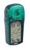
View all Garmin eTrex Venture manuals
Add to My Manuals
Save this manual to your list of manuals |
Page 72 highlights
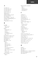
Index Using (continued) Map Page 9-10 Route 33 Track Log 39-40 UTM 21 V Velocity Made Good 14, 18, 21, 53 Vertical Speed 14, 18, 21, 53 View Hunt and Fish 48 Sun and Moon 46 View Waypoints on Route 35, 37 W Warnings iii-iv Warranty vi-vii Water Immersion v Waypoints 24-27 WGS84 (World Geodetic Survey 1984) 42 Wide Area Augmentation System (WAAS) 1, 45 Wiring Diagram 56 www.GARMIN.com vii www.nima.mil 42 Y Yards 42 Z ZOOM IN 9, 10 ZOOM IN button 2 ZOOM OUT 9, 10 ZOOM OUT button 2 62
-
 1
1 -
2
-
3
-
4
-
5
-
6
-
7
-
8
-
9
-
10
-
11
-
12
-
13
-
14
-
15
-
16
-
17
-
18
-
19
-
20
-
21
-
22
-
23
-
24
-
25
-
26
-
27
-
28
-
29
-
30
-
31
-
32
-
33
-
34
-
35
-
36
-
37
-
38
-
39
-
40
-
41
-
42
-
43
-
44
-
45
-
46
-
47
-
48
-
49
-
50
-
51
-
52
-
53
-
54
-
55
-
56
-
57
-
58
-
59
-
60
-
61
-
62
-
63
-
64
-
65
-
66
-
 67
67 -
 68
68 -
 69
69 -
 70
70 -
 71
71 -
 72
72 -
 73
73 -
 74
74 -
 75
75 -
 76
76
 |
 |

62
Using (continued)
Map Page 9–10
Route 33
Track Log 39–40
UTM 21
V
Velocity Made Good 14, 18, 21, 53
Vertical Speed 14, 18, 21, 53
View
Hunt and Fish 48
Sun and Moon 46
View Waypoints on Route 35, 37
W
Warnings iii–iv
Warranty vi–vii
Water Immersion v
Waypoints 24–27
WGS84 (World Geodetic Survey 1984) 42
Wide Area Augmentation System (WAAS) 1,
45
Wiring Diagram 56
www.GARMIN.com vii
www.nima.mil 42
Y
Yards 42
Z
ZOOM IN 9, 10
ZOOM IN button 2
ZOOM OUT 9, 10
ZOOM OUT button 2
Index