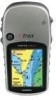
Garmin eTrex Vista HCx Owner's Manual - Page 52
INDEX, eTrex HC series Owner's Manual - specifications
 |
UPC - 753759071134
View all Garmin eTrex Vista HCx manuals
Add to My Manuals
Save this manual to your list of manuals |
Page 52 highlights
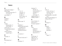
Index Index A adjusting the backlight 4 altimeter page pressure/elevation plots 33 view points 34 auto-routing 21 B backlight 4 batteries 1 C compass bearing pointer 31 course pointer 31 compass page 27 Course Deviation Indicator (CDI) 31 creating waypoints using the map 8 D data fields 25 E Enter/Rocker key 3 48 F find a city 14 a geocache 13 an address 15 by name 10 point of interest 16 waypoints 13 H highway page 36 I initializing 4 installing and removing the microSD card 6 installing batteries 1 installing the lanyard 1 K key functions 3 L log track to data card 17 M main pages 23 map page 24 map data 25 measuring distance 27 orientation 26 setup 39 zoom range 25 mapping databases 5 marking a location 7 P points of interest 16 profile field 32 proximity waypoints 9 R routes creating 20 deleting 22 off-road transition 22 turn previews 22 S satellite page 23 Sight N'Go 30 specifications 45 status bar 5 T tracks 16 saving a track log 17 setting up a track 17 view a track 19 transferring data to a microSD card 5 Trip & Waypoint Manager 46 turning on the unit 3 U units page 38 W waypoints editing 8 moving 8 projecting 9 Z zoom ranges 33 eTrex HC series Owner's Manual
-
 1
1 -
2
-
3
-
4
-
5
-
6
-
7
-
8
-
9
-
10
-
11
-
12
-
13
-
14
-
15
-
16
-
17
-
18
-
19
-
20
-
21
-
22
-
23
-
24
-
25
-
26
-
27
-
28
-
29
-
30
-
31
-
32
-
33
-
34
-
35
-
36
-
37
-
38
-
39
-
40
-
41
-
42
-
43
-
44
-
45
-
46
-
 47
47 -
 48
48 -
 49
49 -
 50
50 -
 51
51 -
 52
52 -
 53
53 -
 54
54
 |
 |
