Lowrance Elite-4 DSI Operation Manual - Page 31
Orientation
 |
View all Lowrance Elite-4 DSI manuals
Add to My Manuals
Save this manual to your list of manuals |
Page 31 highlights
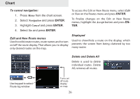
Chart The Record command allows you to record or resume recording a desired trail. Delete and Delete All Delete is used to remove individual trails. Delete All removes all trails. Overlay Data Allows you to select data (course over ground, etc) to be displayed on top of the Chart screen. Orientation Allows you to select North Up or Course Over Ground (COG) as the map orientation. Overlay data Overlay data setup is covered in the Pages section. Settings Accesses the Chart settings menu. North Up COG 29
-
 1
1 -
2
-
3
-
4
-
5
-
6
-
7
-
8
-
9
-
10
-
11
-
12
-
13
-
14
-
15
-
16
-
17
-
18
-
19
-
20
-
21
-
22
-
23
-
24
-
25
-
 26
26 -
 27
27 -
 28
28 -
 29
29 -
 30
30 -
 31
31 -
 32
32 -
 33
33 -
 34
34 -
 35
35 -
 36
36 -
37
-
38
-
39
-
40
-
41
-
42
-
43
-
44
-
45
-
46
-
47
 |
 |

29
Chart
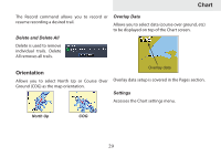
The Record command allows you to record or
resume recording a desired trail.
Delete and Delete All
Delete is used to remove
individual trails. Delete
All removes all trails.
Orientation
Allows you to select North Up or Course Over
Ground (COG) as the map orientation.
Overlay Data
Allows you to select data (course over ground, etc)
to be displayed on top of the Chart screen.
Overlay data setup is covered in the Pages section.
Settings
Accesses the Chart settings menu.
North Up
COG
Overlay data