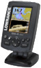
Lowrance Elite-4 DSI Operation Manual - Page 37
Sonar
 |
View all Lowrance Elite-4 DSI manuals
Add to My Manuals
Save this manual to your list of manuals |
Page 37 highlights
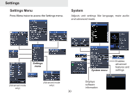
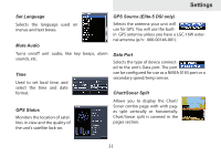
COG Extension A line extending from the front of the current position icon that estimates time and distance it will take to get to areas in front of you. Grid Lines Displays base values for latitude and longitude, making it easier to estimate your location on the latitude/longitude scale. Settings Waypoints, Routes, Trails Accesses the Waypoints, Routes & Trails screen. Waypoints, Routes and Trails are covered in the Chart section. Sonar Used to make adjustments to Sonar options and settings. Waypoints, Routes and Trail displays From the Chart Settings menu, you can turn on/off waypoint, route and trail display properties. Turning off display properties allows you to get a better view of the map, if the screen becomes cluttered with waypoints, routes and/or trails. Sonar Settings Menu Restricts unit's digital depth search capability 35
-
 1
1 -
2
-
3
-
4
-
5
-
6
-
7
-
8
-
9
-
10
-
11
-
12
-
13
-
14
-
15
-
16
-
17
-
18
-
19
-
20
-
21
-
22
-
23
-
24
-
25
-
26
-
27
-
28
-
29
-
30
-
31
-
 32
32 -
 33
33 -
 34
34 -
 35
35 -
 36
36 -
 37
37 -
 38
38 -
 39
39 -
 40
40 -
 41
41 -
 42
42 -
43
-
44
-
45
-
46
-
47
 |
 |
