Lowrance HDS-9 Gen3 Operators Manual US - Page 53
Converting Trails to Routes, Autorouting and Easy Routing - sale
 |
View all Lowrance HDS-9 Gen3 manuals
Add to My Manuals
Save this manual to your list of manuals |
Page 53 highlights
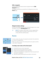
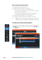
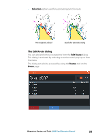
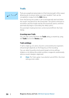
Converting Trails to Routes You can convert a trail to a route from the Edit Trail dialog. The dialog is activated by activating the trail, then selecting the trail's pop-up, or the Trail menu option. The Edit Trails dialog can also be accessed by selecting the Trails tool on the Home page. Autorouting and Easy Routing The Autorouting and Easy Routing suggest new routepoint positions based on information in the map and on your boat's size. Before you can start using this feature the boat draught, width and height must be entered into the system. The boat settings dialog is automatically displayed if the information is missing when you start the feature. Ú Note: HDS Gen3 units designed for sale in the U.S. region do not have Autorouting or Easy Routing capabilities. Autorouting or Easy Routing features are disabled on all non-U.S. units when they are used in U.S. territorial waters. Ú Note: It is not possible to start the Autorouting or Easy Routing if one of the selected routepoints is located in an unsafe area. A warning dialog is displayed, and you have to move the relevant routepoint(s) to a safe area to proceed. Ú Note: If no compatible cartography is available, the Autorouting or Easy Routing menu option is not available. Compatible cartography includes Jeppesen CMAP MAX-N +, Navionics+ and Navionics Platinum. For a full selection of available charts please visit insightstore.navico.com, cmap.jeppesen.com or navionics.com. Waypoints, Routes, and Trails | HDS Gen3 Operator Manual 53
-
 1
1 -
2
-
3
-
4
-
5
-
6
-
7
-
8
-
9
-
10
-
11
-
12
-
13
-
14
-
15
-
16
-
17
-
18
-
19
-
20
-
21
-
22
-
23
-
24
-
25
-
26
-
27
-
28
-
29
-
30
-
31
-
32
-
33
-
34
-
35
-
36
-
37
-
38
-
39
-
40
-
41
-
42
-
43
-
44
-
45
-
46
-
47
-
 48
48 -
 49
49 -
 50
50 -
 51
51 -
 52
52 -
 53
53 -
 54
54 -
 55
55 -
 56
56 -
 57
57 -
 58
58 -
59
-
60
-
61
-
62
-
63
-
64
-
65
-
66
-
67
-
68
-
69
-
70
-
71
-
72
-
73
-
74
-
75
-
76
-
77
-
78
-
79
-
80
-
81
-
82
-
83
-
84
-
85
-
86
-
87
-
88
-
89
-
90
-
91
-
92
-
93
-
94
-
95
-
96
-
97
-
98
-
99
-
100
-
101
-
102
-
103
-
104
-
105
-
106
-
107
-
108
-
109
-
110
-
111
-
112
-
113
-
114
-
115
-
116
-
117
-
118
-
119
-
120
-
121
-
122
-
123
-
124
-
125
-
126
-
127
-
128
-
129
-
130
-
131
-
132
-
133
-
134
-
135
-
136
-
137
-
138
-
139
-
140
-
141
-
142
-
143
-
144
-
145
-
146
-
147
-
148
-
149
-
150
-
151
-
152
-
153
-
154
-
155
-
156
-
157
-
158
-
159
-
160
-
161
-
162
-
163
-
164
-
165
-
166
 |
 |
