Magellan Triton 300 Manual - English - Page 24
The Altimeter / Barometer Screen (Magellan Triton 500), The Satellite Status Screen
 |
UPC - 763357118223
View all Magellan Triton 300 manuals
Add to My Manuals
Save this manual to your list of manuals |
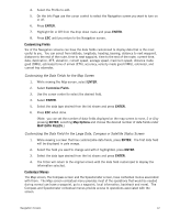
Page 24 highlights
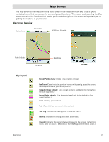
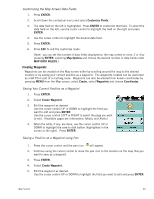
The Altimeter / Barometer Screen (Magellan Triton 500) The Altimeter / Barometer screen displays your current elevation and barometer readings. The Satellite Status Screen The Satellite Status Screen graphically displays the satellites and their signal strength that is being used to compute your location. This screen shows when you are getting strong, weak, or poor signal reception. Green satellite icons represent satellites that are being used to compute your position while yellow (good), white (medium), and red (poor) icons show signal strengths of other available satellites. Signal levels are also represented at the bottom of the screen as colored bars. The numbers indicate the GPS satellite ID while "W" indicates WAAS (Wide Area Augmentation System) satellites. There are also two customizable navigational screens displayed at the bottom of the display. Navigation Screens 16
-
 1
1 -
2
-
3
-
4
-
5
-
6
-
7
-
8
-
9
-
10
-
11
-
12
-
13
-
14
-
15
-
16
-
17
-
18
-
 19
19 -
 20
20 -
 21
21 -
 22
22 -
 23
23 -
 24
24 -
 25
25 -
 26
26 -
 27
27 -
 28
28 -
 29
29 -
30
-
31
-
32
-
33
-
34
-
35
-
36
-
37
-
38
-
39
-
40
-
41
-
42
-
43
-
44
-
45
-
46
-
47
-
48
-
49
-
50
-
51
-
52
-
53
-
54
-
55
-
56
-
57
-
58
-
59
-
60
-
61
-
62
-
63
-
64
-
65
 |
 |
