Alpine INE-W970HD Owners Manual - Page 174
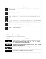
Navigation View settings, Button, Function
 |
View all Alpine INE-W970HD manuals
Add to My Manuals
Save this manual to your list of manuals |
Page 174 highlights
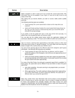
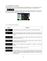
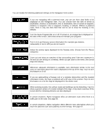
5.3.4 Navigation View settings These settings allow you to fine-tune the appearance of the Navigation view. You can also adjust how the software helps you navigate with different kinds of route-related information on the Navigation view. Tap to adjust the navigation view to your needs, choose suitable color themes from the list for both daytime and nighttime use, show or hide 3D buildings, landmarks, and manage your Place visibility sets (which Places to show on the map). You can modify the following settings: Button Function Adjust the basic zoom and tilt levels to your needs. Three levels are available. Switch between daytime and night color modes or let the software switch between the two modes automatically a few minutes before sunrise and a few minutes after sunset. Select the color scheme used in daytime mode. Daytime colours are bright and similar to paper road maps. Select the color scheme used in night mode. Night colours are darker to keep the average brightness of the screen low. Show or hide 3D landmarks (3D representations of prominent or well-known objects). Show or hide the 3D elevation of the terrain. Select which Places to show on the map while navigating. Too many Places make the map crowded so it is a good idea to keep as few of them on the map as possible. Tap the name of the Place category to show/hide it or to open the list of its subcategories. 75
-
 1
1 -
2
-
3
-
4
-
5
-
6
-
7
-
8
-
9
-
10
-
11
-
12
-
13
-
14
-
15
-
16
-
17
-
18
-
19
-
20
-
21
-
22
-
23
-
24
-
25
-
26
-
27
-
28
-
29
-
30
-
31
-
32
-
33
-
34
-
35
-
36
-
37
-
38
-
39
-
40
-
41
-
42
-
43
-
44
-
45
-
46
-
47
-
48
-
49
-
50
-
51
-
52
-
53
-
54
-
55
-
56
-
57
-
58
-
59
-
60
-
61
-
62
-
63
-
64
-
65
-
66
-
67
-
68
-
69
-
70
-
71
-
72
-
73
-
74
-
75
-
76
-
77
-
78
-
79
-
80
-
81
-
82
-
83
-
84
-
85
-
86
-
87
-
88
-
89
-
90
-
91
-
92
-
93
-
94
-
95
-
96
-
97
-
98
-
99
-
100
-
101
-
102
-
103
-
104
-
105
-
106
-
107
-
108
-
109
-
110
-
111
-
112
-
113
-
114
-
115
-
116
-
117
-
118
-
119
-
120
-
121
-
122
-
123
-
124
-
125
-
126
-
127
-
128
-
129
-
130
-
131
-
132
-
133
-
134
-
135
-
136
-
137
-
138
-
139
-
140
-
141
-
142
-
143
-
144
-
145
-
146
-
147
-
148
-
149
-
150
-
151
-
152
-
153
-
154
-
155
-
156
-
157
-
158
-
159
-
160
-
161
-
162
-
163
-
164
-
165
-
166
-
167
-
168
-
 169
169 -
 170
170 -
 171
171 -
 172
172 -
 173
173 -
 174
174 -
 175
175 -
 176
176 -
 177
177 -
 178
178 -
 179
179 -
180
-
181
-
182
-
183
-
184
-
185
-
186
-
187
-
188
-
189
-
190
-
191
-
192
-
193
-
194
-
195
-
196
-
197
-
198
-
199
 |
 |
