Alpine INE-W970HD Owners Manual - Page 175
information exists, the map is replaced with a 3D view of the junction. Tap it to turn
 |
View all Alpine INE-W970HD manuals
Add to My Manuals
Save this manual to your list of manuals |
Page 175 highlights
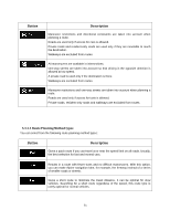
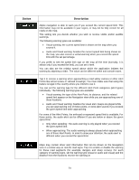
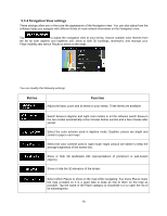
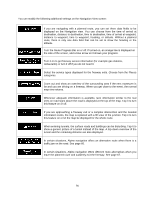
You can modify the following additional settings on the Navigation View screen: If you are navigating with a planned route, you can set three data fields to be displayed on the Navigation view. You can choose from the time of arrival at destination, distance to destination, time to destination, time of arrival at waypoint, distance to waypoint, time to waypoint, heading, or altitude. Without a planned route, there is only one data field that can be set to show the heading or the altitude. Turn the Route Progress Bar on or off. If turned on, an orange line is displayed on the side of the screen, and a blue arrow on it shows your progress. Turn it on to get freeway service information (for example gas stations, restaurants) or turn it off if you do not need it. Select the service types displayed for the freeway exits. Choose from the Places categories. Zoom out and show an overview of the surrounding area if the next maneuver is far and you are driving on a freeway. When you get close to the event, the normal map view returns. Whenever adequate information is available, lane information similar to the real ones on road signs above the road is displayed at the top of the map. Tap it to turn this feature on or off. If you are approaching a freeway exit or a complex intersection and the needed information exists, the map is replaced with a 3D view of the junction. Tap it to turn this feature on or let the map be displayed for the whole route. When entering tunnels, the surface roads and buildings can be disturbing. Tap it to show a generic picture of a tunnel instead of the map. A top-down overview of the tunnel and the remaining distance are also displayed. In certain situations, Alpine navigation offers an alternative route when there is a traffic jam on the road. See page 66. In certain situations, Alpine navigation offers different route alternatives when you leave the planned route and suddenly exit the freeway. See page 67. 76
-
 1
1 -
2
-
3
-
4
-
5
-
6
-
7
-
8
-
9
-
10
-
11
-
12
-
13
-
14
-
15
-
16
-
17
-
18
-
19
-
20
-
21
-
22
-
23
-
24
-
25
-
26
-
27
-
28
-
29
-
30
-
31
-
32
-
33
-
34
-
35
-
36
-
37
-
38
-
39
-
40
-
41
-
42
-
43
-
44
-
45
-
46
-
47
-
48
-
49
-
50
-
51
-
52
-
53
-
54
-
55
-
56
-
57
-
58
-
59
-
60
-
61
-
62
-
63
-
64
-
65
-
66
-
67
-
68
-
69
-
70
-
71
-
72
-
73
-
74
-
75
-
76
-
77
-
78
-
79
-
80
-
81
-
82
-
83
-
84
-
85
-
86
-
87
-
88
-
89
-
90
-
91
-
92
-
93
-
94
-
95
-
96
-
97
-
98
-
99
-
100
-
101
-
102
-
103
-
104
-
105
-
106
-
107
-
108
-
109
-
110
-
111
-
112
-
113
-
114
-
115
-
116
-
117
-
118
-
119
-
120
-
121
-
122
-
123
-
124
-
125
-
126
-
127
-
128
-
129
-
130
-
131
-
132
-
133
-
134
-
135
-
136
-
137
-
138
-
139
-
140
-
141
-
142
-
143
-
144
-
145
-
146
-
147
-
148
-
149
-
150
-
151
-
152
-
153
-
154
-
155
-
156
-
157
-
158
-
159
-
160
-
161
-
162
-
163
-
164
-
165
-
166
-
167
-
168
-
169
-
 170
170 -
 171
171 -
 172
172 -
 173
173 -
 174
174 -
 175
175 -
 176
176 -
 177
177 -
 178
178 -
 179
179 -
 180
180 -
181
-
182
-
183
-
184
-
185
-
186
-
187
-
188
-
189
-
190
-
191
-
192
-
193
-
194
-
195
-
196
-
197
-
198
-
199
 |
 |
