Garmin Oregon 450 Owner's Manual - Page 11
NAviGAtinG to A, DestinAtion - maps
 |
UPC - 753759100537
View all Garmin Oregon 450 manuals
Add to My Manuals
Save this manual to your list of manuals |
Page 11 highlights
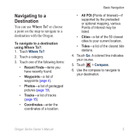
Navigating to a Destination You can use Where To? or choose a point on the map to navigate to a destination with the Oregon. To navigate to a destination using Where To?: 1. Touch Where To?. 2. Touch a category. 3. Touch one of the following items: • Recent Finds-items you have recently found. • Waypoints-a list of waypoints (page 4). • Photos-a list of geotagged pictures (page 19). • Tracks-a list of tracks (page 15). • Coordinates-enter the coordinates of a location. Basic Navigation • All POI (Points of Interest)-if supported by the preloaded or optional mapping, various Points of Interest may be listed. • Cities-a list of the 50 closest cities to your current location. • Tides-a list of the closest tide stations. 4. Touch Go. A colored line indicates your course. 5. Touch > Compass. 6. Use the compass to navigate to your destination. Oregon Series Owner's Manual 5
-
 1
1 -
2
-
3
-
4
-
5
-
 6
6 -
 7
7 -
 8
8 -
 9
9 -
 10
10 -
 11
11 -
 12
12 -
 13
13 -
 14
14 -
 15
15 -
 16
16 -
17
-
18
-
19
-
20
-
21
-
22
-
23
-
24
-
25
-
26
-
27
-
28
-
29
-
30
-
31
-
32
-
33
-
34
-
35
-
36
-
37
-
38
-
39
-
40
-
41
-
42
-
43
-
44
-
45
-
46
-
47
-
48
-
49
-
50
-
51
-
52
 |
 |
