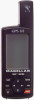
Magellan GPS 315 User Manual - Page 33
To create a message., To delete a message., To save your edits. - instructions for
 |
UPC - 763357101522
View all Magellan GPS 315 manuals
Add to My Manuals
Save this manual to your list of manuals |
Page 33 highlights
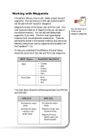
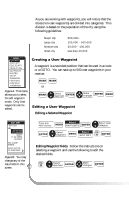
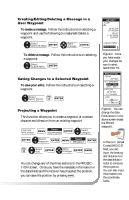
Creating/Editing/Deleting a Message in a User Waypoint To create a message. Follow the instructions on selecting a waypoint and use the following to create/edit/delete a waypoint. Select CREATE MSG ENTER Make changes ENTER EDIT WPT CAMP 34˚06.56N 117˚49.60W 900 FT 11:23:35PM 12JUN97 CREATE MSG SAVE EDITS To delete a message. Follow the instructions on selecting a waypoint. Select CLEAR MSG ENTER Saving Changes to a Selected Waypoint To save your edits. Follow the instructions on selecting a waypoint. Select SAVE EDITS FIG. C ENTER Projecting a Waypoint This function allows you to create a waypoint at a certain distance and direction from an existing waypoint. From any NAV screen Select MENU WAYPOINTS ENTER Select category ENTER Select waypoint ENTER MENU Select PROJECT ENTER FIG. D Select field ENTER Make changes ENTER MARK You can change any of the three sections in the PROJECTION screen. Once you have the necessary information in the data fields and the receiver has projected the position, you can save the position by pressing . MARK Figure C. Once you have made your changes, be sure to select SAVE EDITS. PROJECTION FROM WPT003 G.C. BRG/DST BRG 000˚M DST 000 M I LAT/LON 34˚08.56N 117˚50.60W UTM 11 423760W 37 74479N Figure D. You can change the data fields shown in the above screen except the FROM waypoint. In the G.C. (Great Circle) BRG/DST field, you can input the bearing and distance into the data fields in order to compute the projection. You can also input information into the coordinate fields. Magellan GPS 315/GPS 320 25
-
 1
1 -
2
-
3
-
4
-
5
-
6
-
7
-
8
-
9
-
10
-
11
-
12
-
13
-
14
-
15
-
16
-
17
-
18
-
19
-
20
-
21
-
22
-
23
-
24
-
25
-
26
-
27
-
 28
28 -
 29
29 -
 30
30 -
 31
31 -
 32
32 -
 33
33 -
 34
34 -
 35
35 -
 36
36 -
 37
37 -
 38
38 -
39
-
40
-
41
-
42
-
43
-
44
-
45
-
46
-
47
-
48
-
49
-
50
-
51
-
52
-
53
-
54
-
55
-
56
-
57
-
58
-
59
-
60
-
61
-
62
-
63
-
64
-
65
-
66
-
67
-
68
-
69
-
70
-
71
-
72
-
73
-
74
-
75
-
76
-
77
-
78
 |
 |
