Magellan GPS 315 User Manual - Page 61
Nmea Output Data Format - Version 1.5
 |
UPC - 763357101522
View all Magellan GPS 315 manuals
Add to My Manuals
Save this manual to your list of manuals |
Page 61 highlights
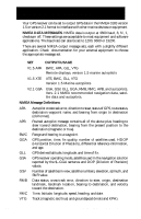
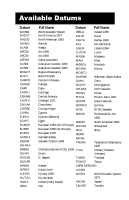
NMEA OUTPUT DATA FORMAT - VERSION 1.5 APA Autopilot Format A 1 2 3 4 5 6 7 8 9 10 APA,A,A,X.XX,L,N,A,A,XXX.,M,CCC 1 OR'ed Blink and SNR (A = valid, V = invalid) 2 Cycle Lock (A = valid, V = invalid) 3-5 Cross Track, Sense (L = steer left, R = steer Right), N.Mi. Units 6-7 Arrival Circle, Arrival Perpendicular (crossing of the line which is perpendicular to the course line and which passes through the destination waypoint. 8-9 Bearing dest. WPT. from origin WPT., Magnetic 10 Dest WPT. identifier BWC To Selected Waypoint, Great Circle 1 2 3 4 5 6 7 8 9 10 1112 BWC,XXXXXX,XXXX.XX,N,XXXXX.XX,W,XXX.,T,XXX.,M,XXX.X,N,CCCC 1 UTC of Bearing 2-3 Lat, N or S of waypoint 4-5 Long, E or W of waypoint 6-7 Bearing, True 8-9 Bearing, Magnetic 10-11Distance, naut. miles 12 Waypoint identifier GLL Geographic Position - Latitude/Longitude 1 2 3 4 5 6 GLL,1111.11,a,yyyyy.yy,a,hhmmss.ss,A*hh 1-2 Latitude, N/S 2-3 Longitude, E/W 4 UTC of position 6 Status A = Data valid Magellan GPS 315/GPS 320 53
-
 1
1 -
2
-
3
-
4
-
5
-
6
-
7
-
8
-
9
-
10
-
11
-
12
-
13
-
14
-
15
-
16
-
17
-
18
-
19
-
20
-
21
-
22
-
23
-
24
-
25
-
26
-
27
-
28
-
29
-
30
-
31
-
32
-
33
-
34
-
35
-
36
-
37
-
38
-
39
-
40
-
41
-
42
-
43
-
44
-
45
-
46
-
47
-
48
-
49
-
50
-
51
-
52
-
53
-
54
-
55
-
 56
56 -
 57
57 -
 58
58 -
 59
59 -
 60
60 -
 61
61 -
 62
62 -
 63
63 -
 64
64 -
 65
65 -
 66
66 -
67
-
68
-
69
-
70
-
71
-
72
-
73
-
74
-
75
-
76
-
77
-
78
 |
 |
