Magellan RoadMate 360 Manual - English - Page 8
Placement of Your GPS Receiver for Optimal Satellite Reception, A Word on the Safe Usage of GPS Maps - vehicle gps
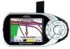 |
UPC - 763357112221
View all Magellan RoadMate 360 manuals
Add to My Manuals
Save this manual to your list of manuals |
Page 8 highlights
Information increase the accuracy of satellite navigation include the use of DGPS (Differential Global-Positioning System); ground relay stations, set at known positions, transmit corrected satellite-navigation signals. Various methods and applications of DGPS can increase satellite navigation accuracy from a few meters to within a few millimeters. Using DGPS requires a differential-beacon receiver and antennae in addition to a satellite-navigation device. Accuracy can also be increased using an RTK (Real-Time Kinematic) satellite-navigation system. This is a receiver capable of transmitting a phase-corrected signal from a known position to one or more rover receivers. A number of positioning errors can occur, limiting accuracy to within 15 to 25 meters. These errors are monitored and compensated for in a number of ways: Orbiting errors -- Occasionally a satellite's reported position does not match its actual trajectory. In the U.S., the Department of Defense continuously monitors each satellite, making orbital corrections with onboard booster rockets. Poor geometry -- If all of the satellites within line of sight of a receiver are clustered closely together, or lined up relative to the position of the receiver, the geometric calculations necessary for triangulating a position become difficult and less reliable. The use of differential-correction signals from satellite-based augmentation systems or DGPS can compensate for both orbital errors and poor geometry. Multipath signals -- Signals may be reflected off tall buildings or other obstructions before reaching the receiver, increasing the distance a signal travels and reducing accuracy. Thales Navigation receivers make a number of complex mathematical calculations to effectively compensate for other potential errors in positioning: Atmospheric delay -- Satellite-navigation signals slow as they pass through the Earth's atmosphere. Thales Navigation receivers calculate the average delay in nanoseconds to compensate. Clock errors -- The clock built into a receiver is not as accurate as the atomic clock on a navigation satellite, which is accurate to one second every million years. Each Thales Navigation receiver compensates for time differentials by comparing the time signals of several satellites and adjusting its calculations and its clock to match. Placement of Your GPS Receiver for Optimal Satellite Reception FIrstly, before considering signal reception, it is important to understand that your GPS receiver is a sensitive piece of equipment. You should never place it in an area of your vehicle where it may be struck by other items, or where vibration may cause it to strike other items or parts of the vehicle. The windshield mount included in the box allows you to place the receiver in such a way that the antenna can receive the satellite signal through the windshield without being obstructed by other parts of the vehicle. However, tinted windows or other reflective coatings may interfere with reception. In this case, it may be required to attach an external antenna (optional). The external antenna mounts to the outside of your vehicle and is therefore not hampered by tinted windows. Other mounting solutions are available but may require and external antenna. External conditions also affect GPS signal reception. Although weather conditions do not affect the signal, tall buildings and trees, driving through canyons, wooded areas, or tunnels, and sitting in a garage or covered parking area will affect the GPS signal. The GPS receiver constantly monitors and updated the GPS signal status and will reacquire the signal once it is clear of any obstructions. A Word on the Safe Usage of GPS Maps Just like paper maps, maps on GPS devices vary greatly in terms of information included and visual presentation. Whether topographical maps, roadmaps or marine charts, each map and the data it presents is designed for a specific purpose. For example, marine charts will often present only a minimal representation of roadways and are not a substitute for street maps. Topographic maps usually provide minimal detail about bodies of water, and do not contain marine navigational markers. Maps also vary widely in scale: the smaller the scale, the more detailed the map. Therefore, when using GPS maps (just as with paper maps) it is important to consider what type of map you are using in your explorations and to use common sense. From Source to Destination Thales Navigation, maker of Magellan GPS products, is not a cartography company. We do not create the maps that are used on our GPS devices. We seek to acquire map data from the best public and private sources available at the 2
-
 1
1 -
2
-
 3
3 -
 4
4 -
 5
5 -
 6
6 -
 7
7 -
 8
8 -
 9
9 -
 10
10 -
 11
11 -
 12
12 -
 13
13 -
14
-
15
-
16
-
17
-
18
-
19
-
20
-
21
-
22
-
23
-
24
-
25
-
26
-
27
-
28
-
29
-
30
-
31
-
32
-
33
-
34
-
35
-
36
-
37
-
38
-
39
-
40
-
41
-
42
-
43
-
44
-
45
-
46
-
47
-
48
-
49
-
50
-
51
-
52
-
53
-
54
-
55
-
56
-
57
-
58
-
59
-
60
-
61
-
62
-
63
-
64
-
65
-
66
-
67
-
68
-
69
-
70
-
71
-
72
-
73
-
74
-
75
-
76
-
77
-
78
-
79
-
80
-
81
-
82
-
83
-
84
-
85
-
86
-
87
-
88
-
89
-
90
-
91
-
92
-
93
-
94
-
95
 |
 |
