Pioneer AVIC-U250 Owner's Manual - Page 23
Frequently shown route, events, Seeing the current position, on the map, How to use the map
 |
View all Pioneer AVIC-U250 manuals
Add to My Manuals
Save this manual to your list of manuals |
Page 23 highlights
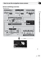
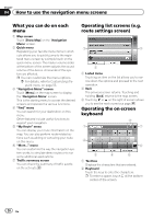
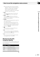
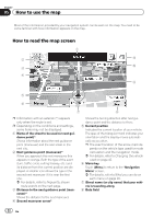
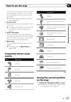
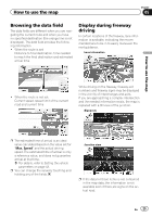
How to use the map Chapter 05 How to use the map Touching this field displays route information Icon during navigation. By default, only one data field is displayed. Touch this field to see all data fields. = For details, refer to Browsing the data field on page 25. 9 Current route* The route currently set is highlighted in color on the map. = For details of the POI icons, refer to Cus- tomizing the map screen settings on page 57. a Traffic information The recommended route is not always the same between two points. Whenever suitable data exists, traffic information can be taken into account in the route calculation. b Quick menu Touching this key causes the quick menu to appear. = For details, refer to Quick menu on page 20. Frequently shown route events Icon Description Turn left. Turn right. Description Keep left. Continue straight in the intersection. Go left on the traffic circle, 3rd exit (next maneuver). Enter traffic circle (second next maneuver). Enter freeway. Exit freeway. Board ferry. Leave ferry. Approaching a waypoint. Approaching the destination. Turn back. Bear right. Turn sharp left. Seeing the current position on the map 1 Display the "Navigation Menu" screen. = For details of the operations, refer to Screen switching overview on page 19. En 23
-
 1
1 -
2
-
3
-
4
-
5
-
6
-
7
-
8
-
9
-
10
-
11
-
12
-
13
-
14
-
15
-
16
-
17
-
 18
18 -
 19
19 -
 20
20 -
 21
21 -
 22
22 -
 23
23 -
 24
24 -
 25
25 -
 26
26 -
 27
27 -
 28
28 -
29
-
30
-
31
-
32
-
33
-
34
-
35
-
36
-
37
-
38
-
39
-
40
-
41
-
42
-
43
-
44
-
45
-
46
-
47
-
48
-
49
-
50
-
51
-
52
-
53
-
54
-
55
-
56
-
57
-
58
-
59
-
60
-
61
-
62
-
63
-
64
-
65
-
66
-
67
-
68
-
69
-
70
-
71
-
72
-
73
-
74
-
75
-
76
 |
 |
