Pioneer AVIC-U250 Owner's Manual - Page 25
Browsing the data field, Display during freeway, driving, How to use the map
 |
View all Pioneer AVIC-U250 manuals
Add to My Manuals
Save this manual to your list of manuals |
Page 25 highlights
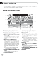
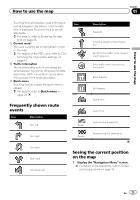
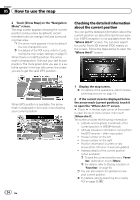
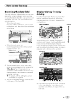
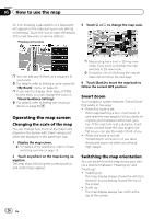
How to use the map Chapter 05 Browsing the data field The data fields are different when you are navigating the current route and when you have no specified destination (the orange line is not displayed). The data field provides the following information. ! When the route is set: Distance to final destination, time needed to reach the final destination and estimated arrival time Display during freeway driving In certain locations of the freeway, lane information is available, indicating the recommended lane to be in to easily maneuver the next guidance. Lane information How to use the map ! When the route is not set: Current speed, speed limit of the current road and current time While driving on the freeway, freeway exit numbers and freeway signs may be displayed in the vicinity of interchanges and exits. If you are approaching a complex intersection and the needed information exists, the map is replaced with a 3D view of the junction. Signposts p The estimated time of arrival is an ideal value calculated based on the value set for "Max. Speed" and the actual driving speed. The estimated time of arrival is only a reference value, and does not guarantee arrival at that time. = For details, refer to Setting the vehicle parameters on page 43. p You can change the value by touching and holding any of the fields. Junction view p If the data for these items is not contained in the map data, the information is not available even if there are signs on the actual road. En 25
-
 1
1 -
2
-
3
-
4
-
5
-
6
-
7
-
8
-
9
-
10
-
11
-
12
-
13
-
14
-
15
-
16
-
17
-
18
-
19
-
 20
20 -
 21
21 -
 22
22 -
 23
23 -
 24
24 -
 25
25 -
 26
26 -
 27
27 -
 28
28 -
 29
29 -
 30
30 -
31
-
32
-
33
-
34
-
35
-
36
-
37
-
38
-
39
-
40
-
41
-
42
-
43
-
44
-
45
-
46
-
47
-
48
-
49
-
50
-
51
-
52
-
53
-
54
-
55
-
56
-
57
-
58
-
59
-
60
-
61
-
62
-
63
-
64
-
65
-
66
-
67
-
68
-
69
-
70
-
71
-
72
-
73
-
74
-
75
-
76
 |
 |
