Garmin GPSMAP 4208 Owner's Manual - Page 60
Position Tracking, Configuring Vessel Trails on the Navigation Chart
 |
UPC - 753759066048
View all Garmin GPSMAP 4208 manuals
Add to My Manuals
Save this manual to your list of manuals |
Page 60 highlights
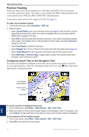
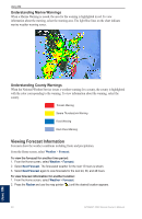
Digital Selective Calling Position Tracking When you connect your Garmin chartplotter to a VHF radio using NMEA 0183, you can track vessels that send position reports. This feature is also available with NMEA 2000, provided that the vessel sends the correct PGN data (PGN 129808; DSC Call Information). Every position report call received is logged in the DSC list (page 32). To view a list of position reports: 1. From the Home screen, select Information > DSC List. 2. Select an option: • Select Call with Radio to set up an individual routine call (page 57) with the radio to call the vessel that sent the position report. This option is available only if you are using a Garmin NMEA 2000-compatible VHF radio. • Select Edit to edit the vessel name and add a comment. If your radio is tracking the position of the vessel, select Trail to show or hide the trail line for the vessel, and select Trail Line to change the line color. • Select Clear Report to delete the call report. • Select Navigate To to Go To or Route To the location sent with the position report (page 23). • Select Create Waypoint to set a waypoint at the location sent with the position report. • Select Next Page or Previous Page to toggle between details of the position report and a Navigation chart marking the location. Configuring Vessel Trails on the Navigation Chart If you have your chartplotter configured to show trails, the Navigation chart displays a black dot for each reported position, a black line indicating the path of the vessel, and a Blue Flag symbol indicating the last reported position. Last-reported vessel position Position-report location Vessel trail Vessel Trail To set the duration of displayed trail points: 1. From a chart screen, select Menu > Other Vessels > DSC > DSC Trails. 2. Select the number of hours to show tracked vessels on the Navigation chart. For example, if you select 4 Hours, all trail points that are less than four hours old for tracked vessels are displayed. To turn trail lines off for tracked vessels: 1. From a chart screen, select Menu > Other Vessels > DSC > DSC Trails. 2. Select Off to turn trails off for every vessel. 56 GPSMAP 4000 Series Owner's Manual DSC
-
 1
1 -
2
-
3
-
4
-
5
-
6
-
7
-
8
-
9
-
10
-
11
-
12
-
13
-
14
-
15
-
16
-
17
-
18
-
19
-
20
-
21
-
22
-
23
-
24
-
25
-
26
-
27
-
28
-
29
-
30
-
31
-
32
-
33
-
34
-
35
-
36
-
37
-
38
-
39
-
40
-
41
-
42
-
43
-
44
-
45
-
46
-
47
-
48
-
49
-
50
-
51
-
52
-
53
-
54
-
 55
55 -
 56
56 -
 57
57 -
 58
58 -
 59
59 -
 60
60 -
 61
61 -
 62
62 -
 63
63 -
 64
64 -
 65
65 -
66
-
67
-
68
-
69
-
70
-
71
-
72
-
73
-
74
-
75
-
76
-
77
-
78
-
79
-
80
-
81
-
82
-
83
-
84
 |
 |
