Garmin GPSMAP 5215 Owner's Manual - Page 75
Distress Call Received from <name>, DSC Position Report Received From <name>
 |
View all Garmin GPSMAP 5215 manuals
Add to My Manuals
Save this manual to your list of manuals |
Page 75 highlights
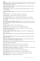
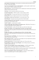
Appendix Directory Memory is Full Can't Create Entry-DSC directory is full, no more entries can be created. Distress Call Received from -distress call has been received by the DSC module. Drift Alarm-boat has moved a user-defined distance. DSC Position Report Received From -a position report has been received by the DSC module. Entering Target Water Temperature-(temperature sensor/transducer) the water temperature is inside the user-defined target temperature zone. Flash Flood Warning Alarm-(XM WX weather) there is a flash flood warning in effect. Flood Warning Alarm-(XM WX weather) there is a flood warning effective. GPS Accuracy Alarm-the GPS accuracy has fallen outside the user-set value. GPS Antenna Has Lost Its Stored Settings-The GPS antenna's memory has been cleared. Contact product support. GPS Service Incompatible. Software Update Required-a GPS service software update is needed. Contact product support for assistance updating your chartplotter software. GPS Service Lost-the chartplotter has lost communications with the remote GPS device. Check the network and the antenna wiring. Incompatible Device, Software Update Required-an incompatible device is attached that requires a software update. Contact product support for assistance updating your network. Invalid Date-an invalid date was entered. Invalid Device Instance. Enter a number between (0 - 252)-invalid NMEA 2000 Device instance. Invalid Entry. Default value selected.-an invalid entry was entered. Invalid MMSI-an invalid DSC MMSI was entered. Invalid System Instance. Enter a number between (0 - 15)-invalid NMEA 2000 System instance. Leaving Target Water Temperature-(temperature sensor/transducer) the water temperature is outside the user-defined target temperature zone. Lost Heading Sensor Connection- (radar/NMEA) the chartplotter has lost communications with the heading sensor. Check wiring. Lost Remote GPS Connection-lost connection to the remote GPS. Check the network and the antenna wiring. Lost Satellite Reception-the chartplotter has lost satellite reception. Make sure you have a clear view of the sky. Low Fuel Alarm-(NMEA 2000) low fuel reported by the NMEA 2000 network. Map Format Is Not Supported-a map format on a preprogrammed SD card is not supported. Marine Weather Warning-(XM WX weather) there is a weather warning in effect. MARPA: Dangerous Target-(radar) a MARPA target has become dangerous. MARPA: Target Lost-(radar) unable to track a marpa target any longer. GPSMAP 5000 Series Owner's Manual 71
-
 1
1 -
2
-
3
-
4
-
5
-
6
-
7
-
8
-
9
-
10
-
11
-
12
-
13
-
14
-
15
-
16
-
17
-
18
-
19
-
20
-
21
-
22
-
23
-
24
-
25
-
26
-
27
-
28
-
29
-
30
-
31
-
32
-
33
-
34
-
35
-
36
-
37
-
38
-
39
-
40
-
41
-
42
-
43
-
44
-
45
-
46
-
47
-
48
-
49
-
50
-
51
-
52
-
53
-
54
-
55
-
56
-
57
-
58
-
59
-
60
-
61
-
62
-
63
-
64
-
65
-
66
-
67
-
68
-
69
-
 70
70 -
 71
71 -
 72
72 -
 73
73 -
 74
74 -
 75
75 -
 76
76 -
 77
77 -
 78
78 -
 79
79 -
 80
80 -
81
-
82
-
83
-
84
 |
 |
