Garmin GPSMAP 5215 Owner's Manual - Page 81
GPSMAP 5000 Series Owner's Manual, Service Points
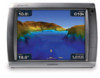 |
View all Garmin GPSMAP 5215 manuals
Add to My Manuals
Save this manual to your list of manuals |
Page 81 highlights
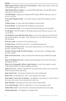
P panning 9 photos 11, 18 POI data 19 position 37 precipitation information 59 preferred devices 38 pressure center 62 gradient 64 isobars 64 unit settings 37 product registration 74 projected path 60 R radar 45 cross talk 49 fast time constant 49 overlay screen 48 surface 13 range rings 13 rear panel 1 reset 4 review 26 rings 11, 50 Roses 11 routes cancel 27 creating 27 deleting 29 editing 29 route to 23 S safe depth 13, 40 height 37 satellite imagery 18 signals 3 save preset (XM) 42, 66 scroll speed 53 SD cards inserting and removing 3 using 16 search for destination 24 Service Points 11 settings chart 11 communications 38 severe thunderstorm warning 61 simulator mode 4, 36 software version 4 sonar 51 A-scope 53 advanced settings 53 depth line 53 gain 54 range 53 scroll speed 53 setting up 53 sonar cone 17 sonar data 18 specifications 67 speed unit settings 37 split frequency radar 52 split zoom radar 51 spot depths 12 stationary front 62 storm cells 59 sunrise/sunset 31 surface noise 53 surface radar 13 surface winds 62 symbols 8, 12 system information 4 T targeting (radar) 47, 48 temperature 37 temp log 52 tides/currents 11 tide station 30 tide stations 10 time 38 time zone 38 tornado warning 61 tracks 14, 18 editing/deleting 18 transfer data 32 transmit radar 45 tropical depression 60 tropical storm 60 trough 62 true north 37 U units of measure changing 37 user data clearing 32 transferring 33 viewing 32 user mag var 37 V video viewing 35 viewing currents 30 user data 32 visibility 64 Vision BlueChart g2 15 volume unit settings 37 VRM/EBL adjusting 49 W warm front 62 warnings county 61 marine 61 warranty 74 water speed (calibrate) 40 temperature 64 wave direction 62 height 63 period 62 waypoints 13 creating 10, 25 deleting 25, 26 edit existing 13 editing 26 list of 26 viewing 32 waypoints & tracks 6 weather data 59 fronts 62 Where To 23 whiteline 53 wind barb 63 surface 62 wireless devices 38 X XM audio 42, 59, 66 XM weather 59 Z zoom 6, 12, 17, 19, 54 Index GPSMAP 5000 Series Owner's Manual 77
-
 1
1 -
2
-
3
-
4
-
5
-
6
-
7
-
8
-
9
-
10
-
11
-
12
-
13
-
14
-
15
-
16
-
17
-
18
-
19
-
20
-
21
-
22
-
23
-
24
-
25
-
26
-
27
-
28
-
29
-
30
-
31
-
32
-
33
-
34
-
35
-
36
-
37
-
38
-
39
-
40
-
41
-
42
-
43
-
44
-
45
-
46
-
47
-
48
-
49
-
50
-
51
-
52
-
53
-
54
-
55
-
56
-
57
-
58
-
59
-
60
-
61
-
62
-
63
-
64
-
65
-
66
-
67
-
68
-
69
-
70
-
71
-
72
-
73
-
74
-
75
-
 76
76 -
 77
77 -
 78
78 -
 79
79 -
 80
80 -
 81
81 -
 82
82 -
 83
83 -
 84
84
 |
 |
