Garmin GPSMAP 525 Owner's Manual - Page 24
Using Fishing Charts, Tracks, Data Bars, Navaids
 |
UPC - 753759066116
View all Garmin GPSMAP 525 manuals
Add to My Manuals
Save this manual to your list of manuals |
Page 24 highlights
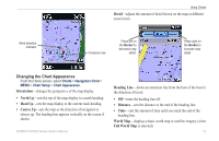
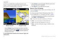
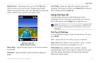
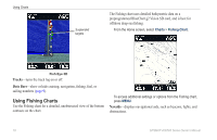
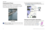
Using Charts Suspended targets The Fishing chart uses detailed bathymetric data on a preprogrammed BlueChart g2 Vision SD card, and is best for offshore deep-sea fishing. From the Home screen, select Charts > Fishing Chart. Fish Eye 3D Tracks-turns the track log on or off. Data Bars-show or hide cruising, navigation, fishing, fuel, or sailing numbers (page 9). Using Fishing Charts Use the Fishing chart for a detailed, unobstructed view of the bottom contours on the chart. To access additional settings or options from the Fishing chart, press MENU. Navaids-displays navigational aids, such as beacons, lights, and obstructions. 18 GPSMAP 400/500 Series Owner's Manual
-
 1
1 -
2
-
3
-
4
-
5
-
6
-
7
-
8
-
9
-
10
-
11
-
12
-
13
-
14
-
15
-
16
-
17
-
18
-
 19
19 -
 20
20 -
 21
21 -
 22
22 -
 23
23 -
 24
24 -
 25
25 -
 26
26 -
 27
27 -
 28
28 -
 29
29 -
30
-
31
-
32
-
33
-
34
-
35
-
36
-
37
-
38
-
39
-
40
-
41
-
42
-
43
-
44
-
45
-
46
-
47
-
48
-
49
-
50
-
51
-
52
-
53
-
54
-
55
-
56
-
57
-
58
-
59
-
60
-
61
-
62
-
63
-
64
-
65
-
66
-
67
-
68
-
69
-
70
-
71
-
72
 |
 |

±
GPSMAP 400/500 Series Owner’s Manual
Using Charts
Suspended
targets
Fish Eye 3D
Tracks
—turns the track log on or off.
Data Bars
—show or hide cruising, navigation, fishing, fuel, or
sailing numbers (
page 9
).
Using Fishing Charts
Use the Fishing chart for a detailed, unobstructed view of the bottom
contours on the chart.
The Fishing chart uses detailed bathymetric data on a
preprogrammed BlueChart g2 Vision SD card, and is best for
offshore deep-sea fishing.
From the Home screen, select
Charts
>
Fishing Chart
.
To access additional settings or options from the Fishing chart,
press
MENU
.
Navaids
—displays navigational aids, such as beacons, lights, and
obstructions.