ii
GPSMAP 400/500 Series Owner’s Manual
Introduction
Table of Contents
Introduction
...........................................................................
i
Tips and Shortcuts
........................................................................
i
Manual Conventions
.....................................................................
i
Quick Links
...................................................................................
i
Declaration of Conformity (DoC)
..................................................
iv
Product Registration
....................................................................
iv
Contact Garmin
............................................................................
iv
Getting Started
.....................................................................
1
Unit Overview
...............................................................................
1
Turning the Unit On or Off
............................................................
3
Initializing Unit Settings
................................................................
3
Adjusting the Backlight
.................................................................
4
Using the Keypad
.........................................................................
5
Acquiring GPS Satellite Signals
...................................................
5
Using Simulator Mode
..................................................................
6
Viewing System Information
........................................................
6
Restoring the Original Factory Settings
.......................................
6
Inserting and Removing SD Cards
..............................................
6
Understanding the Home Screen
.................................................
7
Using Charts
........................................................................
8
Using the Navigation Chart
..........................................................
8
Changing the Navigation Chart Settings
....................................
12
Using the Split Navigation Chart
................................................
14
Using Perspective 3D
................................................................
15
Using Mariner’s Eye 3D
.............................................................
15
Using Fish Eye 3D
.....................................................................
17
Using Fishing Charts
..................................................................
18
Enabling High Resolution Satellite Imagery
...............................
19
Viewing Aerial Photos
................................................................
20
Viewing Current-station Information
...........................................
20
Detailed Road and POI Data
.....................................................
21
Using Automatic Guidance
.........................................................
21
Using the Chart/Sonar Screen
...................................................
21
Where To?
..........................................................................
22
Navigating to a Destination
........................................................
22
Creating and Using Waypoints
...................................................
24
Creating and Using Routes
........................................................
25
Using Tracks
..............................................................................
26
Using BlueChart g2 Vision
.........................................................
28
Navigating with a Garmin Autopilot
............................................
29
Viewing Information
..........................................................
30
Viewing a Compass
...................................................................
30
Viewing Numbers
.......................................................................
30
Viewing Trip Information
............................................................
31
Viewing Fuel Gauges
.................................................................
31
Viewing Tide-station Information
................................................
32
Viewing Current Information
......................................................
32
Viewing User Data
.....................................................................
33
Viewing Other Vessels
...............................................................
35
 1
1 2
2 3
3 4
4 5
5 6
6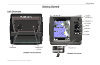 7
7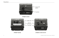 8
8 9
9 10
10