Garmin GPSMAP 60CS Owner's Manual - Page 76
Enter, Enter.
 |
UPC - 753759044060
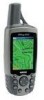
View all Garmin GPSMAP 60CS manuals
Add to My Manuals
Save this manual to your list of manuals |
Page 76 highlights
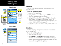
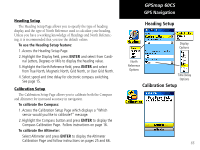
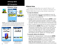
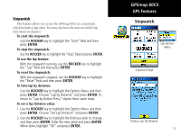
GPSmap 60CS GPS Navigation Altimeter Setup Important - If you select the "Save Always" option, be certain to switch back to the "Save When Power On" option before removing the batteries from the unit and when storing the unit for long periods with batteries in place. If not, you may need to reset your location for satellite acquisition at the next start-up. Enter the correct elevation 66 Enter the correct barometric pressure Altimeter Setup The Altimeter Setup Page allows you to setup the Altimeter to self calibrate each time you turn on the unit, to function as a barometer or to manually calibrate when you have accurate elevation or pressure data. To setup the Altimeter: 1. Access the Altimeter Setup Page and highlight the Auto Cali bration field and press ENTER to select from On or Off. When On, elevation is corrected by GPS. 2. Highlight the Barometer Mode field and press ENTER to select Variable Elevation (used when moving) or Fixed Elevation (used when stationary, allowing the Altimeter to function as a standard barometer). Trip data is not recorded when in Fixed Elevation mode. 3. Select a method of saving data from the Pressure Trend Recording field and press ENTER. When you select "Save Always," the pressure is recorded every 15 minutes, even when the unit is turned off. For this reason be certain to return this setting back to "Save When Power On" when removing batteries or storing the unit with batteries for prolonged periods. Install fresh batteries when the "Battery Low" message appears. To manually calibrate the Altimeter: 1. Highlight the "Calibrate Altimeter" button and press ENTER. You can calibrate the Altimeter using one of three methods: Enter the correct elevation: this requires a reliable source for determining the elevation for your current location. Enter the correct pressure: this requires a reliable source to determine the accurate barometric pressure at your current location.
-
 1
1 -
2
-
3
-
4
-
5
-
6
-
7
-
8
-
9
-
10
-
11
-
12
-
13
-
14
-
15
-
16
-
17
-
18
-
19
-
20
-
21
-
22
-
23
-
24
-
25
-
26
-
27
-
28
-
29
-
30
-
31
-
32
-
33
-
34
-
35
-
36
-
37
-
38
-
39
-
40
-
41
-
42
-
43
-
44
-
45
-
46
-
47
-
48
-
49
-
50
-
51
-
52
-
53
-
54
-
55
-
56
-
57
-
58
-
59
-
60
-
61
-
62
-
63
-
64
-
65
-
66
-
67
-
68
-
69
-
70
-
 71
71 -
 72
72 -
 73
73 -
 74
74 -
 75
75 -
 76
76 -
 77
77 -
 78
78 -
 79
79 -
 80
80 -
 81
81 -
82
-
83
-
84
-
85
-
86
-
87
-
88
-
89
-
90
-
91
-
92
-
93
-
94
-
95
-
96
-
97
-
98
-
99
-
100
-
101
-
102
-
103
-
104
-
105
-
106
-
107
-
108
 |
 |
