Garmin GPSMAP 62st Owner's Manual - Page 26
Customizing Your Device, Customizing Data Fields, Data Field Options - accessories
 |
View all Garmin GPSMAP 62st manuals
Add to My Manuals
Save this manual to your list of manuals |
Page 26 highlights
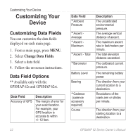
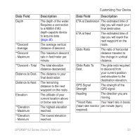
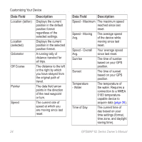
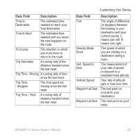
Customizing Your Device Customizing Your Device Customizing Data Fields You can customize the data fields displayed on each main page. 1. From a main page, press meNu. 2. Select Change Data Fields. 3. Select a data field. 4. Follow the on-screen instructions. Data Field Options ** Available only with the GPSMAP 62s and GPSMAP 62st. Data Field Accuracy of GPS Description The margin of error for your exact location. For example, your GPS location is accurate to within +/- 12 feet. Data Field **Ambient Pressure **Ascent Average **Ascent Maximum **Ascent - Total **Barometer Battery Level Bearing **Cadence (cadence accessory required) Course Description The uncalibrated environmental pressure. The average vertical distance of ascent. The maximum ascent rate in feet/meters per minute. The total elevation distance ascended. The calibrated current pressure. The remaining battery power. The direction from your current location to a destination. Revolutions of the crank arm or strides per minute. The direction from your starting location to a destination. 22 GPSMAP 62 Series Owner's Manual
-
 1
1 -
2
-
3
-
4
-
5
-
6
-
7
-
8
-
9
-
10
-
11
-
12
-
13
-
14
-
15
-
16
-
17
-
18
-
19
-
20
-
 21
21 -
 22
22 -
 23
23 -
 24
24 -
 25
25 -
 26
26 -
 27
27 -
 28
28 -
 29
29 -
 30
30 -
 31
31 -
32
-
33
-
34
-
35
-
36
-
37
-
38
-
39
-
40
-
41
-
42
-
43
-
44
-
45
-
46
-
47
-
48
-
49
-
50
-
51
-
52
-
53
-
54
-
55
-
56
 |
 |
