| Section |
Page |
| Table of Contents |
3 |
| Introduction |
9 |
| Protective Cover |
9 |
| Device Overview |
9 |
| Using the Touchscreen |
9 |
| On-Screen Buttons |
9 |
| Locking and Unlocking the Touchscreen |
9 |
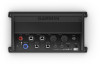
| Connector View (10, 12, and 16-inch models) |
9 |
| Connector View (17, 22, and 24-inch models) |
10 |
| Connector View (8700 models) |
10 |
| Tips and Shortcuts (MFD models) |
10 |
| Tips and Shortcuts (8700 model) |
10 |
| Accessing Owner's Manuals on the Chartplotter |
10 |
| Downloading the Manuals from the Web |
10 |
| Garmin Support Center |
11 |
| Memory Cards |
11 |
| Inserting Memory Cards (10, 12, and 16-inch models) |
11 |
| Inserting a Memory Card (17, 22, and 24-inch models and 8700) |
11 |
| Acquiring GPS Satellite Signals |
11 |
| Selecting the GPS Source |
11 |
| Customizing the Chartplotter |
11 |
| Home Screen |
11 |
| Adding an Item to Favorites |
12 |
| Customizing the Home Screen |
12 |
| Customizing Pages |
12 |
| Customizing the Layout of a SmartMode or Combination Page |
12 |
| Changing the Background Image |
12 |
| Recommended Background Image Dimensions |
12 |
| Customizing the Startup Screen |
12 |
| Recommended Startup Image Dimensions |
12 |
| Adding a SmartMode Layout |
12 |
| Creating a New Combination Page |
13 |
| Deleting a Combination Page |
13 |
| Customizing the Data Overlays |
13 |
| Resetting the Station Layouts |
13 |
| Presets |
13 |
| Saving a New Preset |
13 |
| Managing Presets |
13 |
| Setting the Vessel Type |
13 |
| Adjusting the Backlight |
14 |
| Adjusting the Color Mode |
14 |
| Turning On the Chartplotter Automatically |
14 |
| Enabling Screen Lock |
14 |
| Automatically Turning Off the System |
14 |
| ActiveCaptain App |
14 |
| ActiveCaptain Roles |
14 |
| Getting Started with the ActiveCaptain App |
14 |
| Enabling Smart Notifications |
15 |
| Receiving Notifications |
15 |
| Managing Notifications |
15 |
| Making Notifications Private |
15 |
| Updating Software with the ActiveCaptain App |
15 |
| Updating Charts with ActiveCaptain |
15 |
| Communication with Wireless Devices |
16 |
| Wi‑Fi Network |
16 |
| Setting Up the Wi‑Fi Wireless Network |
16 |
| Connecting a Wireless Device to the Chartplotter |
16 |
| Changing the Wireless Channel |
16 |
| Changing the Wi‑Fi Host |
16 |
| Wireless Remote Control |
16 |
| Pairing the Wireless Remote Control With the Chartplotter |
16 |
| Turning On and Off the Remote Backlight |
16 |
| Disconnecting the Remote from All Chartplotters |
16 |
| Wireless Wind Sensor |
16 |
| Connecting a Wireless Sensor to the Chartplotter |
16 |
| Adjusting the Wind Sensor Orientation |
16 |
| Viewing Boat Data on a Garmin Watch |
16 |
| Viewing Boat Data on a Garmin Nautix™ Device |
17 |
| Charts and 3D Chart Views |
17 |
| Navigation Chart and Fishing Chart |
17 |
| Zooming In and Out Using the Touchscreen |
17 |
| Chart Symbols |
17 |
| Measuring a Distance on the Chart |
17 |
| Creating a Waypoint on the Chart |
18 |
| Viewing Location and Object Information on a Chart |
18 |
| Viewing Details about Navaids |
18 |
| Navigating to a Point on the Chart |
18 |
| Premium Charts |
18 |
| Fish Eye 3D Chart View |
18 |
| Viewing Tide Station Information |
18 |
| Animated Tide and Current Indicators |
19 |
| Showing Tides and Current Indicators |
19 |
| Showing Satellite Imagery on the Navigation Chart |
19 |
| Viewing Aerial Photos of Landmarks |
19 |
| Automatic Identification System |
19 |
| AIS Targeting Symbols |
19 |
| Heading and Projected Course of Activated AIS Targets |
20 |
| Activating a Target for an AIS Vessel |
20 |
| Viewing Information about a Targeted AIS Vessel |
20 |
| Deactivating a Target for an AIS Vessel |
20 |
| Viewing a List of AIS and MARPA Threats |
20 |
| Setting the Safe-Zone Collision Alarm |
20 |
| AIS Aids to Navigation |
20 |
| AIS Distress Signals |
20 |
| Navigating to a Distress Signal Transmission |
20 |
| AIS Distress Signal Device Targeting Symbols |
21 |
| Enabling AIS Transmission Test Alerts |
21 |
| Turning Off AIS Reception |
21 |
| Chart Menu |
21 |
| Chart Layers |
21 |
| Chart Layer Settings |
21 |
| Depth Layer Settings |
21 |
| My Vessel Layer Settings |
21 |
| Laylines Settings |
22 |
| User Data Layer Settings |
22 |
| Other Vessels Layer Settings |
22 |
| Water Layer Settings |
22 |
| Depth Range Shading |
22 |
| Weather Layer Settings |
22 |
| Radar Overlay Settings |
23 |
| Chart Settings |
23 |
| Fish Eye 3D Settings |
23 |
| Supported Maps |
23 |
| Garmin Quickdraw Contours Mapping |
23 |
| Mapping a Body of Water Using the Garmin Quickdraw Contours Feature |
23 |
| Adding a Label to a Garmin Quickdraw Contours Map |
23 |
| Garmin Quickdraw Community |
23 |
| Connecting to the Garmin Quickdraw Community with ActiveCaptain |
24 |
| Downloading Garmin Quickdraw Community Maps Using ActiveCaptain |
24 |
| Sharing Your Garmin Quickdraw Contours Maps with the Garmin Quickdraw Community Using ActiveCaptain |
24 |
| Connecting to the Garmin Quickdraw Community with Garmin Connect |
24 |
| Sharing Your Garmin Quickdraw Contours Maps with the Garmin Quickdraw Community Using Garmin Connect |
24 |
| Downloading Garmin Quickdraw Community Maps Using Garmin Connect |
24 |
| Garmin Quickdraw Contours Settings |
24 |
| Navigation with a Chartplotter |
25 |
| Basic Navigation Questions |
25 |
| Destinations |
25 |
| Searching for a Destination by Name |
25 |
| Selecting a Destination Using the Navigation Chart |
25 |
| Searching for a Marine Services Destination |
25 |
| Setting and Following a Direct Course Using Go To |
26 |
| Stopping Navigation |
26 |
| Waypoints |
26 |
| Marking Your Present Location as a Waypoint |
26 |
| Creating a Waypoint at a Different Location |
26 |
| Marking an SOS Location |
26 |
| Projecting a Waypoint |
26 |
| Viewing a List of all Waypoints |
26 |
| Editing a Saved Waypoint |
26 |
| Moving a Saved Waypoint |
26 |
| Browsing for and Navigating to a Saved Waypoint |
26 |
| Deleting a Waypoint or an MOB |
27 |
| Deleting All Waypoints |
27 |
| Routes |
27 |
| Creating and Navigating a Route From Your Present Location |
27 |
| Creating and Saving a Route |
27 |
| Viewing a List of Routes and Auto Guidance Paths |
27 |
| Editing a Saved Route |
27 |
| Browsing for and Navigating a Saved Route |
27 |
| Browsing for and Navigating Parallel to a Saved Route |
27 |
| Initiating a Search Pattern |
28 |
| Deleting a Saved Route |
28 |
| Deleting All Saved Routes |
28 |
| Auto Guidance |
28 |
| Setting and Following an Auto Guidance Path |
28 |
| Creating and Saving an Auto Guidance Path |
28 |
| Adjusting a Saved Auto Guidance Path |
28 |
| Canceling an Auto Guidance Calculation in Progress |
28 |
| Setting a Timed Arrival |
28 |
| Auto Guidance Path Configurations |
28 |
| Adjusting the Distance from Shore |
29 |
| Tracks |
29 |
| Showing Tracks |
29 |
| Setting the Color of the Active Track |
29 |
| Saving the Active Track |
29 |
| Viewing a List of Saved Tracks |
29 |
| Editing a Saved Track |
29 |
| Saving a Track as a Route |
29 |
| Browsing for and Navigating a Recorded Track |
29 |
| Deleting a Saved Track |
30 |
| Deleting All Saved Tracks |
30 |
| Retracing the Active Track |
30 |
| Clearing the Active Track |
30 |
| Managing the Track Log Memory During Recording |
30 |
| Configuring the Recording Interval of the Track Log |
30 |
| Boundaries |
30 |
| Creating a Boundary |
30 |
| Converting a Route to a Boundary |
30 |
| Converting a Track to a Boundary |
30 |
| Editing a Boundary |
30 |
| Linking a Boundary to a SmartMode Layout |
30 |
| Setting a Boundary Alarm |
30 |
| Disabling all Boundary Alarms |
31 |
| Deleting a Boundary |
31 |
| Deleting All Saved Waypoints, Tracks, Routes, and Boundaries |
31 |
| Sailing Features |
31 |
| Setting the Vessel Type |
31 |
| Sail Racing |
31 |
| Starting Line Guidance |
31 |
| Setting the Starting Line |
31 |
| Using the Starting Line Guidance |
31 |
| Starting the Race Timer |
31 |
| Stopping the Race Timer |
31 |
| Setting the Distance between the Bow and the GPS Antenna |
31 |
| Laylines Settings |
31 |
| Setting the Keel Offset |
32 |
| Sailboat Autopilot Operation |
32 |
| Wind Hold |
32 |
| Setting the Wind Hold Type |
32 |
| Engaging Wind Hold |
32 |
| Engaging Wind Hold from Heading Hold |
32 |
| Adjusting the Wind Hold Angle with the Autopilot |
32 |
| Tack and Gybe |
32 |
| Tacking and Gybing from Heading Hold |
32 |
| Tacking and Gybing from Wind Hold |
32 |
| Setting a Tack and Gybe Delay |
32 |
| Enabling the Gybe Inhibitor |
33 |
| Heading Line and Angle Markers |
33 |
| Setting the Heading Line and Angle Markers |
33 |
| Sonar Fishfinder |
33 |
| Stopping the Transmission of Sonar Signals |
33 |
| Changing the Sonar View |
33 |
| Traditional Sonar View |
33 |
| Split-Frequency Sonar View |
33 |
| Split-Zoom Sonar View |
33 |
| Garmin ClearVü Sonar View |
33 |
| SideVü Sonar View |
34 |
| SideVü Scanning Technology |
34 |
| Measuring Distance on the Sonar Screen |
34 |
| Panoptix Sonar Views |
34 |
| LiveVü Down Sonar View |
34 |
| LiveVü Forward Sonar View |
35 |
| RealVü 3D Forward Sonar View |
35 |
| RealVü 3D Down Sonar View |
35 |
| RealVü 3D Historical Sonar View |
35 |
| FrontVü Sonar View |
35 |
| Panoptix LiveScope Sonar View |
35 |
| Perspective View |
36 |
| Selecting the Transducer Type |
36 |
| Selecting a Sonar Source |
36 |
| Renaming a Sonar Source |
36 |
| Creating a Waypoint on the Sonar Screen |
36 |
| Pausing the Sonar Display |
36 |
| Viewing Sonar History |
36 |
| Sonar Sharing |
36 |
| Adjusting the Level of Detail |
36 |
| Adjusting the Color Intensity |
36 |
| Sonar Recordings |
37 |
| Recording the Sonar Display |
37 |
| Stopping the Sonar Recording |
37 |
| Deleting a Sonar Recording |
37 |
| Playing Sonar Recordings |
37 |
| Traditional, Garmin ClearVü, and SideVü Sonar Setup |
37 |
| Setting the Zoom Level on the Sonar Screen |
37 |
| Setting the Scroll Speed |
37 |
| Adjusting the Range of the Depth or Width Scale |
38 |
| Sonar Noise Rejection Settings |
38 |
| Sonar Appearance Settings |
38 |
| Sonar Alarms |
38 |
| Advanced Sonar Settings |
39 |
| Traditional, Garmin ClearVü, and SideVü Transducer Installation Settings |
39 |
| Sonar Frequencies |
39 |
| Selecting the Transducer Frequency |
39 |
| Creating a Frequency Preset |
39 |
| Turning On the A-Scope |
39 |
| Panoptix Sonar Setup |
40 |
| Zooming in a Panoptix LiveVü or LiveScope Sonar View |
40 |
| Adjusting the RealVü Viewing Angle and Zoom Level |
40 |
| Adjusting the RealVü Sweep Speed |
40 |
| LiveVü Forward and FrontVü Sonar Menu |
40 |
| Setting the LiveVü and FrontVü Transducer Transmit Angle |
40 |
| Setting the FrontVü Depth Alarm |
41 |
| LiveVü and FrontVü Appearance Settings |
41 |
| RealVü Appearance Settings |
41 |
| Perspective Appearance Settings |
41 |
| Panoptix Transducer Installation Settings |
41 |
| Setting the Bow Offset |
41 |
| Calibrating the Compass |
42 |
| Radar |
42 |
| Radar Interpretation |
42 |
| Radar Overlay |
42 |
| Radar Overlay and Chart Data Alignment |
42 |
| Transmitting Radar Signals |
43 |
| Stopping the Transmission of Radar Signals |
43 |
| Setting Up the Timed Transmit Mode |
43 |
| Enabling and Adjusting a Radar No Transmit Zone |
43 |
| Adjusting the Radar Range |
43 |
| Tips for Selecting a Radar Range |
43 |
| MotionScope™ Doppler Radar Technology |
43 |
| Enabling a Guard Zone |
43 |
| Defining a Circular Guard Zone |
43 |
| Defining a Partial Guard Zone |
43 |
| MARPA |
44 |
| MARPA Targeting Symbols |
44 |
| Acquiring MARPA Targets Automatically |
44 |
| Assigning a MARPA Tag to an Object |
44 |
| Removing a MARPA Tag from a Targeted Object |
44 |
| Viewing Information about a MARPA-tagged Object |
44 |
| Viewing a List of AIS and MARPA Threats |
44 |
| Showing AIS Vessels on the Radar Screen |
44 |
| VRM and EBL |
44 |
| Showing and Adjusting the VRM and the EBL |
44 |
| Measuring the Range and Bearing to a Target Object |
44 |
| Echo Trails |
45 |
| Turning on Echo Trails |
45 |
| Adjusting the Length of the Echo Trails |
45 |
| Clearing the Echo Trails |
45 |
| Radar Settings |
45 |
| Radar Gain |
45 |
| Adjusting Gain on the Radar Screen Automatically |
45 |
| Adjusting Gain on the Radar Screen Manually |
45 |
| Minimizing Nearby Large-Object Interference |
45 |
| Minimizing Side-Lobe Interference on the Radar Screen |
45 |
| Radar Filter Settings |
45 |
| Adjusting Sea Clutter on the Radar Screen |
45 |
| Adjusting Rain Clutter on the Radar Screen |
46 |
| Averaging Multiple Scans on the Radar Screen |
46 |
| Radar Options Menu |
46 |
| Radar Setup Menu |
46 |
| Reducing Cross Talk Clutter on the Radar Screen |
46 |
| Radar Appearance Settings |
46 |
| Radar Installation Settings |
46 |
| Front-of-Boat Offset |
46 |
| Measuring the Potential Front-of-Boat Offset |
46 |
| Setting the Front-of-Boat Offset |
47 |
| Setting a Custom Park Position |
47 |
| Radar My Vessel Layer Settings |
47 |
| Selecting a Different Radar Source |
47 |
| Changing the Radar Mode |
47 |
| Autopilot |
47 |
| Opening the Autopilot Screen |
47 |
| Autopilot Screen |
47 |
| Adjusting the Step Steering Increment |
47 |
| Setting the Power Saver |
47 |
| Enabling Shadow Drive™ |
47 |
| Selecting the Preferred Heading Source |
47 |
| Autopilot Overlay Bar |
48 |
| Engaging the Autopilot |
48 |
| Adjusting the Heading with the Helm |
48 |
| Adjusting the Heading with the Chartplotter in Step Steering Mode |
48 |
| Steering Patterns |
48 |
| Following the U-Turn Pattern |
48 |
| Setting Up and Following the Circles Pattern |
48 |
| Setting Up and Following the Zigzag Pattern |
48 |
| Following the Williamson Turn Pattern |
48 |
| Following an Orbit Pattern |
48 |
| Setting Up and Following the Cloverleaf Pattern |
48 |
| Setting Up and Following a Search Pattern |
48 |
| Cancelling a Steering Pattern |
49 |
| Adjusting the Autopilot Response |
49 |
| Enabling the Autopilot Controls on a Garmin Watch |
49 |
| Customizing the Autopilot Button Actions |
49 |
| Controlling the Autopilot with a GRID 20 Remote Control |
49 |
| Reactor™ Autopilot Remote Control |
49 |
| Pairing a Reactor Autopilot Remote Control With a Chartplotter |
49 |
| Changing the Functions of the Reactor Autopilot Remote Control Action Keys |
49 |
| Updating the Reactor Autopilot Remote Control Software |
49 |
| Yamaha Autopilot |
49 |
| Yamaha Autopilot Screen |
50 |
| Yamaha Autopilot Settings |
50 |
| Yamaha Autopilot Overlay Bar |
50 |
| Force® Trolling Motor Control |
50 |
| Connecting to a Trolling Motor |
50 |
| Adding the Trolling Motor Controls to Screens |
50 |
| Trolling Motor Control Bar |
50 |
| Trolling Motor Settings |
51 |
| Assigning a Shortcut to the Trolling Motor Remote Control Shortcut Keys |
51 |
| Calibrating the Trolling Motor Compass |
51 |
| Setting the Bow Offset |
51 |
| Digital Selective Calling |
51 |
| Networked Chartplotter and VHF Radio Functionality |
51 |
| Turning On DSC |
51 |
| DSC List |
52 |
| Viewing the DSC List |
52 |
| Adding a DSC Contact |
52 |
| Incoming Distress Calls |
52 |
| Navigating to a Vessel in Distress |
52 |
| Man-Overboard Distress Calls Initiated from a VHF Radio |
52 |
| Man-Overboard and SOS Distress Calls Initiated from the Chartplotter |
52 |
| Position Tracking |
52 |
| Viewing a Position Report |
52 |
| Navigating to a Tracked Vessel |
52 |
| Creating a Waypoint at the Position of a Tracked Vessel |
52 |
| Editing Information in a Position Report |
52 |
| Deleting a Position-Report Call |
52 |
| Viewing Vessel Trails on the Chart |
52 |
| Individual Routine Calls |
52 |
| Selecting a DSC Channel |
52 |
| Making an Individual Routine Call |
53 |
| Making an Individual Routine Call to an AIS Target |
53 |
| Gauges and Graphs |
53 |
| Viewing the Gauges |
53 |
| Changing the Data Shown in a Gauge |
53 |
| Customizing the Gauges |
53 |
| Customizing Engine Gauge and Fuel Gauge Limits |
53 |
| Selecting the Number of Engines Shown in Gauges |
53 |
| Customizing the Engines Shown in Gauges |
53 |
| Enabling Status Alarms for Engine Gauges |
53 |
| Enabling Some Engine Gauge Status Alarms |
53 |
| Yamaha Engine Gauges |
53 |
| Engine Condition Icons |
54 |
| Engine Alert Icons |
54 |
| Setting Up the Gauges |
54 |
| Configuring the Number of Engines |
54 |
| Configuring the Tank Level Sensors |
54 |
| Changing the Data Shown |
54 |
| Yamaha Engine Data Settings |
54 |
| Setting the Fuel Alarm |
54 |
| Setting the Fuel Capacity of the Vessel |
55 |
| Synchronizing the Fuel Data with the Actual Vessel Fuel |
55 |
| Viewing the Wind Gauges |
55 |
| Configuring the Sailing Wind Gauge |
55 |
| Configuring the Speed Source |
55 |
| Configuring the Heading Source of the Wind Gauge |
55 |
| Customizing the Close-Hauled Wind Gauge |
55 |
| Viewing Trip Gauges |
55 |
| Resetting Trip Gauges |
55 |
| Battery Management |
55 |
| Setting Up the Battery Management Page |
55 |
| Viewing Graphs |
55 |
| Setting the Graph Range and Time Scales |
55 |
| inReach® Messages |
56 |
| Connecting an inReach Device to the Chartplotter |
56 |
| Receiving inReach Messages |
56 |
| Sending an inReach Preset Message |
56 |
| Replying to an inReach Message |
56 |
| Digital Switching |
56 |
| Adding and Editing a Digital Switching Page |
56 |
| Dometic® Optimus® Features |
56 |
| Activating the Optimus Overlay Bar |
56 |
| Optimus Overlay Bar Overview |
56 |
| Optimus Overlay Symbols |
57 |
| Optimus Limp Home Mode |
57 |
| Tide, Current, and Celestial Information |
57 |
| Tide Station Information |
57 |
| Current Station Information |
57 |
| Celestial Information |
57 |
| Viewing Tide Station, Current Station, or Celestial Information for a Different Date |
57 |
| Viewing Information for a Different Tide or Current Station |
57 |
| Viewing Almanac Information from the Navigation Chart |
57 |
| Warning Manager |
57 |
| Viewing Messages |
57 |
| Sorting and Filtering Messages |
57 |
| Saving Messages to a Memory Card |
57 |
| Clearing all of the Messages |
57 |
| Media Player |
57 |
| Opening the Media Player |
58 |
| Media Player Icons |
58 |
| Selecting the Media Device and Source |
58 |
| Playing Music |
58 |
| Browsing for Music |
58 |
| Enabling Alphabetical Search |
58 |
| Setting a Song to Repeat |
58 |
| Setting All Songs to Repeat |
58 |
| Setting Songs to Shuffle |
58 |
| Joining the Fusion PartyBus™ Network |
58 |
| Adjusting the Volume |
58 |
| Muting the Media Volume |
58 |
| Enabling and Disabling Zones |
58 |
| VHF Radio |
58 |
| Scanning VHF Channels |
58 |
| Adjusting the VHF Squelch |
58 |
| Radio |
58 |
| Setting the Tuner Region |
58 |
| Changing the Radio Station |
58 |
| Changing the Tuning Mode |
58 |
| Presets |
59 |
| Saving a Station as a Preset |
59 |
| Selecting a Preset |
59 |
| Removing a Preset |
59 |
| DAB Playback |
59 |
| Setting the DAB Tuner Region |
59 |
| Scanning for DAB Stations |
59 |
| Changing DAB Stations |
59 |
| Selecting a DAB Station from a List |
59 |
| Selecting a DAB Station from a Category |
59 |
| DAB Presets |
59 |
| Saving a DAB Station as a Preset |
59 |
| Selecting a DAB Preset from a List |
59 |
| Removing DAB Presets |
59 |
| SiriusXM Satellite Radio |
59 |
| Locating a SiriusXM Radio ID |
59 |
| Activating a SiriusXM Subscription |
59 |
| Customizing the Channel Guide |
59 |
| Saving a SiriusXM Channel to the Presets List |
60 |
| Parental Controls |
60 |
| Unlocking SiriusXM Parental Controls |
60 |
| Setting Parental Controls on SiriusXM Radio Channels |
60 |
| Clearing All Locked Channels on a SiriusXM Radio |
60 |
| Restoring Default Parental Control Settings Values |
60 |
| Changing a Parental Passcode on a SiriusXM Radio |
60 |
| Setting the Device Name |
60 |
| Updating the Media Player Software |
60 |
| Audio Return Channel |
60 |
| SiriusXM Weather |
60 |
| SiriusXM Equipment and Subscription Requirements |
60 |
| Weather Data Broadcasts |
61 |
| Weather Warnings and Weather Bulletins |
61 |
| Changing the Weather Chart |
61 |
| Viewing Precipitation Information |
61 |
| Storm Cell and Lightning Information |
61 |
| Hurricane Information |
61 |
| Forecast Information |
61 |
| Viewing a Marine Forecast or an Offshore Forecast |
61 |
| Viewing Forecast Information for Another Time Period |
61 |
| Weather Fronts and Pressure Centers |
61 |
| City Forecasts |
61 |
| Viewing Fish Mapping Data |
62 |
| Viewing Sea Conditions |
62 |
| Surface Winds |
62 |
| Wave Height, Wave Period, and Wave Direction |
62 |
| Viewing Forecast Sea Conditions Information for Another Time Period |
62 |
| Viewing Sea Temperature Information |
62 |
| Surface Pressure and Water Temperature Data |
62 |
| Changing the Sea Surface Temperature Color Range |
62 |
| Visibility Information |
62 |
| Viewing Forecast Visibility Information for Another Time Period |
62 |
| Viewing Buoy Reports |
62 |
| Viewing Local Weather Information near a Buoy |
62 |
| Weather Overlay |
62 |
| Viewing Weather Subscription Information |
63 |
| Viewing Video |
63 |
| Selecting a Video Source |
63 |
| Alternating Among Multiple Video Sources |
63 |
| Networked Video Devices |
63 |
| Using Video Presets on Networked Video Cameras |
63 |
| Saving Video Presets on a Networked Video Camera |
63 |
| Naming Video Presets on a Networked Video Camera |
63 |
| Activating Video Presets on a Networked Video Camera |
63 |
| Camera Settings |
63 |
| Video Settings |
63 |
| Associating the Camera to a Video Source |
64 |
| Video Camera Movement Control |
64 |
| Controlling Video Cameras Using On-Screen Controls |
64 |
| Controlling a Video Camera Using Gestures |
64 |
| Configuring the Video Appearance |
64 |
| Garmin VIRB® Action Cameras |
64 |
| Connecting a VIRB 360 Action Camera |
64 |
| Connecting a VIRB Action Camera |
64 |
| Controlling the VIRB Action Camera with the Chartplotter |
65 |
| Controlling the VIRB Action Camera Video Playback |
65 |
| Deleting a VIRB Video |
65 |
| Starting a VIRB Video Slideshow |
65 |
| VIRB Action Camera Settings |
65 |
| VIRB Action Camera Video Setup Settings |
65 |
| Adding the VIRB Action Camera Controls to Other Screens |
65 |
| HDMI Video Considerations |
65 |
| Controlling HDMI Audio |
66 |
| Pairing the GC™ 100 Camera with a Garmin Chartplotter |
66 |
| Device Configuration |
66 |
| System Settings |
66 |
| Sounds and Display Settings |
66 |
| Audio Settings |
66 |
| GPS Settings |
67 |
| Station Settings |
67 |
| Viewing System Software Information |
67 |
| Viewing the Event Log |
67 |
| Viewing E-label Regulatory and Compliance Information |
67 |
| Preferences Settings |
67 |
| Units Settings |
67 |
| Navigation Settings |
67 |
| Auto Guidance Path Configurations |
67 |
| Adjusting the Distance from Shore |
68 |
| Communications Settings |
68 |
| NMEA 0183 Settings |
68 |
| Configuring NMEA 0183 Output Sentences |
68 |
| Setting the Communication Format for Each NMEA 0183 Port |
68 |
| NMEA 2000 Settings |
69 |
| Naming Devices and Sensors on the Network |
69 |
| Marine Network |
69 |
| Setting Alarms |
69 |
| Navigation Alarms |
69 |
| Setting the Anchor Drag Alarm |
69 |
| System Alarms |
69 |
| Sonar Alarms |
69 |
| Setting Weather Alarms |
69 |
| Setting the Fuel Alarm |
69 |
| My Vessel Settings |
69 |
| Setting the Keel Offset |
70 |
| Setting the Water Temperature Offset |
70 |
| Calibrating a Water-Speed Device |
70 |
| Other Vessels Settings |
70 |
| Settings that are Synced on the Garmin Marine Network |
71 |
| Restoring the Original Chartplotter Factory Settings |
71 |
| Sharing and Managing User Data |
71 |
| Copying Waypoints, Routes, and Tracks from HomePort to a Chartplotter |
71 |
| Selecting a File Type for Third-Party Waypoints and Routes |
71 |
| Copying User Data from a Memory Card |
71 |
| Copying User Data to a Memory Card |
72 |
| Copying Built-In Maps to a Memory Card |
72 |
| Updating Built-In Maps with a Memory Card and Garmin Express |
72 |
| Backing Up Data to a Computer |
72 |
| Restoring Backup Data to a Chartplotter |
72 |
| Saving System Information to a Memory Card |
72 |
| Appendix |
72 |
| Registering Your Device with Garmin Express |
72 |
| Software Update |
73 |
| Loading the New Software on a Memory Card |
73 |
| Updating the Device Software |
73 |
| NMEA 0183 with Audio Cable Pinout |
73 |
| Touchscreen Controls for a Connected Computer (MFD models) |
73 |
| Touchscreen Controls for a Connected Computer (8700 Model) |
74 |
| Controlling a Computer with the Chartplotter |
74 |
| Pairing the GRID Device with the Chartplotter from the Chartplotter |
74 |
| Pairing the GRID Device with the Chartplotter from the GRID Device |
74 |
| Rotating the GRID Remote Input Device |
74 |
| Cleaning the Screen |
75 |
| Viewing Images on a Memory card |
75 |
| Screenshots |
75 |
| Capturing Screenshots |
75 |
| Copying Screenshots to a Computer |
75 |
| Troubleshooting |
75 |
| My device will not acquire GPS signals |
75 |
| My device will not turn on or keeps turning off |
75 |
| My device is not creating waypoints in the correct location |
75 |
| Contacting Garmin Support |
75 |
| Specifications |
76 |
| GPSMAP 8x10 Specifications |
76 |
| GPSMAP 8x12 Specifications |
76 |
| GPSMAP 8x16 Specifications |
76 |
| GPSMAP 8x17 Specifications |
76 |
| GPSMAP 8x22 Specifications |
77 |
| GPSMAP 8x24 Specifications |
77 |
| GPSMAP 8700 Specifications |
77 |
| Sonar Models Specifications |
78 |
| NMEA 2000 PGN Information |
78 |
| J1939 Information |
78 |
| NMEA 0183 Information |
79 |
 1
1 3
3 4
4 5
5 6
6 7
7 8
8 9
9 10
10 11
11 12
12 13
13

