Garmin Geko 301 Owner's Manual - Page 19
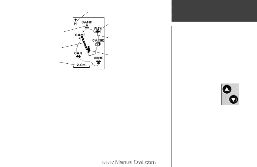
What can I find, on the Map?
 |
UPC - 753759042073
View all Garmin Geko 301 manuals
Add to My Manuals
Save this manual to your list of manuals |
Page 19 highlights
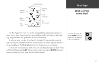
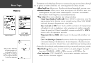
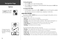
Waypoint Symbol Path to Destination Map Scale Heading Indicator Waypoint Name 'Trail' (track log) 'You' (your location) Map Page What can I find on the Map? The Map Page shows where you are (the animated figure) and provides a picture of where you are going. As you travel (the animated figure 'walks') and leaves a 'trail' (track log). Waypoint names and symbols are also shown on the map. To help you better visualize the 'real world', the Geko 301 automatically rotates the map as you move, so that waypoints that are ahead of you are always displayed in front of the animated figure. The Heading Indicator shows the direction you are heading. To make sure you can see your entire route, you can change the map scale (from 50 feet to 800 miles) by pressing the UP Button to view a larger area, and the DOWN Button for viewing a smaller area (hold down buttons for a faster zoom). When on the Map Page, the UP and DOWN Buttons are used to adjust the map scale from 50 feet to 800 miles. 7
-
 1
1 -
2
-
3
-
4
-
5
-
6
-
7
-
8
-
9
-
10
-
11
-
12
-
13
-
 14
14 -
 15
15 -
 16
16 -
 17
17 -
 18
18 -
 19
19 -
 20
20 -
 21
21 -
 22
22 -
 23
23 -
 24
24 -
25
-
26
-
27
-
28
-
29
-
30
-
31
-
32
-
33
-
34
-
35
-
36
-
37
-
38
-
39
-
40
-
41
-
42
-
43
-
44
-
45
-
46
-
47
-
48
-
49
-
50
-
51
-
52
-
53
-
54
-
55
-
56
-
57
-
58
-
59
-
60
-
61
-
62
-
63
-
64
-
65
-
66
-
67
-
68
 |
 |