Garmin aera 560 Pilot's Guide - Page 118
SafeTaxi Cycle Number and Revision, Enabling/disabling SafeTaxi
 |
View all Garmin aera 560 manuals
Add to My Manuals
Save this manual to your list of manuals |
Page 118 highlights
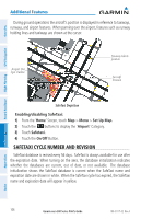
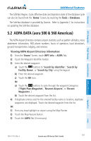
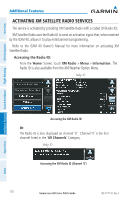
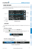
Overview GPS Navigation Additional Features Hazard Avoidance Flight Planning Additional Features During ground operations the aircraft's position is displayed in reference to taxiways, runways, and airport features. When panning over the airport, features such as runway holding lines and taxiways are shown at the cursor. Airport Hot Spot Outline Taxiway Identification Aircraft Position SafeTaxi Depiction Enabling/disabling SafeTaxi: 1) From the 'Home' Screen, touch Map > Menu > Set Up Map. 2) Touch the buttons to display the 'Airport' Category. 3) Touch Safetaxi. 4) Touch the On/Off Button. SafeTaxi Cycle Number and Revision SafeTaxi database is revised every 56 days. SafeTaxi is always available for use after the expiration date. When turning on the aera, the database initialization indicates whether the databases are current, out of date, or not available. The database initialization shows the SafeTaxi database is current when the SafeTaxi name and expiration date are shown in white. When the SafeTaxi cycle has expired, the SafeTaxi name and expiration date will appear in yellow. Appendices Index 106 Garmin aera 500 Series Pilot's Guide 190-01117-02 Rev. A
-
 1
1 -
2
-
3
-
4
-
5
-
6
-
7
-
8
-
9
-
10
-
11
-
12
-
13
-
14
-
15
-
16
-
17
-
18
-
19
-
20
-
21
-
22
-
23
-
24
-
25
-
26
-
27
-
28
-
29
-
30
-
31
-
32
-
33
-
34
-
35
-
36
-
37
-
38
-
39
-
40
-
41
-
42
-
43
-
44
-
45
-
46
-
47
-
48
-
49
-
50
-
51
-
52
-
53
-
54
-
55
-
56
-
57
-
58
-
59
-
60
-
61
-
62
-
63
-
64
-
65
-
66
-
67
-
68
-
69
-
70
-
71
-
72
-
73
-
74
-
75
-
76
-
77
-
78
-
79
-
80
-
81
-
82
-
83
-
84
-
85
-
86
-
87
-
88
-
89
-
90
-
91
-
92
-
93
-
94
-
95
-
96
-
97
-
98
-
99
-
100
-
101
-
102
-
103
-
104
-
105
-
106
-
107
-
108
-
109
-
110
-
111
-
112
-
 113
113 -
 114
114 -
 115
115 -
 116
116 -
 117
117 -
 118
118 -
 119
119 -
 120
120 -
 121
121 -
 122
122 -
 123
123 -
124
-
125
-
126
-
127
-
128
-
129
-
130
-
131
-
132
-
133
-
134
-
135
-
136
-
137
-
138
-
139
-
140
-
141
-
142
-
143
-
144
-
145
-
146
-
147
-
148
-
149
-
150
-
151
-
152
-
153
-
154
-
155
-
156
-
157
-
158
-
159
-
160
-
161
-
162
-
163
-
164
-
165
-
166
-
167
-
168
-
169
-
170
-
171
-
172
-
173
-
174
-
175
-
176
-
177
-
178
-
179
-
180
-
181
-
182
-
183
-
184
-
185
-
186
-
187
-
188
-
189
-
190
-
191
-
192
-
193
-
194
-
195
-
196
-
197
-
198
-
199
-
200
-
201
-
202
 |
 |
