Garmin aera 660 aera 660 Pilot s Guide - Page 100
NEXRAD Abnormalities, NEXRAD Limitations
 |
View all Garmin aera 660 manuals
Add to My Manuals
Save this manual to your list of manuals |
Page 100 highlights
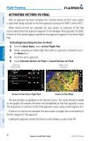
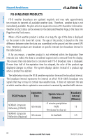
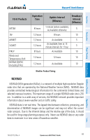
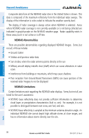
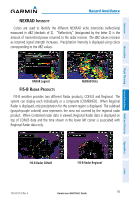
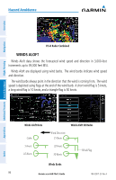
Overview Navigation Additional Features Hazard Avoidance Flight Planning Hazard Avoidance Composite data from all the NEXRAD radar sites in the United States is shown. This data is composed of the maximum reflectivity from the individual radar sweeps. The display of the information is color-coded to indicate the weather severity level. The display of radar coverage is always active when NEXRAD is selected. Areas where NEXRAD radar coverage is not currently available or is not being collected are indicated in grayish-purple on the NEXRAD weather page. Radar capability exists in these areas, but it is not active or is off-line. NEXRAD Abnormalities There are possible abnormalities regarding displayed NEXRAD images. Some, but not all, of those include: • Ground clutter • Strobes and spurious radar data • Sun strobes, when the radar antenna points directly at the sun • Military aircraft deploy metallic dust (chaff) which can cause alterations in radar scans • Interference from buildings or mountains, which may cause shadows • Poor reception from Ground Based Transceivers (GBTs) can cause portions of the received radar imagery to not be displayed NEXRAD Limitations Certain limitations exist regarding the NEXRAD radar displays. Some, but not all, are listed for the user's awareness: • NEXRAD base reflectivity does not provide sufficient information to determine cloud layers or precipitation characteristics (hail vs. rain). For example, it is not possible to distinguish between wet snow, wet hail, and rain. • NEXRAD base reflectivity is sampled at the minimum antenna elevation angle. An individual NEXRAD site cannot depict high altitude storms at close ranges, and has no information about storms directly over the site. Appendices Index 84 Garmin aera 660 Pilot's Guide 190-02017-20 Rev. A
-
 1
1 -
2
-
3
-
4
-
5
-
6
-
7
-
8
-
9
-
10
-
11
-
12
-
13
-
14
-
15
-
16
-
17
-
18
-
19
-
20
-
21
-
22
-
23
-
24
-
25
-
26
-
27
-
28
-
29
-
30
-
31
-
32
-
33
-
34
-
35
-
36
-
37
-
38
-
39
-
40
-
41
-
42
-
43
-
44
-
45
-
46
-
47
-
48
-
49
-
50
-
51
-
52
-
53
-
54
-
55
-
56
-
57
-
58
-
59
-
60
-
61
-
62
-
63
-
64
-
65
-
66
-
67
-
68
-
69
-
70
-
71
-
72
-
73
-
74
-
75
-
76
-
77
-
78
-
79
-
80
-
81
-
82
-
83
-
84
-
85
-
86
-
87
-
88
-
89
-
90
-
91
-
92
-
93
-
94
-
 95
95 -
 96
96 -
 97
97 -
 98
98 -
 99
99 -
 100
100 -
 101
101 -
 102
102 -
 103
103 -
 104
104 -
 105
105 -
106
-
107
-
108
-
109
-
110
-
111
-
112
-
113
-
114
-
115
-
116
-
117
-
118
-
119
-
120
-
121
-
122
-
123
-
124
-
125
-
126
-
127
-
128
-
129
-
130
-
131
-
132
-
133
-
134
-
135
-
136
-
137
-
138
-
139
-
140
-
141
-
142
-
143
-
144
-
145
-
146
-
147
-
148
-
149
-
150
-
151
-
152
-
153
-
154
-
155
-
156
-
157
-
158
-
159
-
160
-
161
-
162
-
163
-
164
-
165
-
166
-
167
-
168
-
169
-
170
-
171
-
172
-
173
-
174
-
175
-
176
-
177
-
178
-
179
-
180
-
181
-
182
-
183
-
184
-
185
-
186
-
187
-
188
-
189
-
190
-
191
-
192
-
193
-
194
-
195
-
196
-
197
-
198
-
199
-
200
-
201
-
202
-
203
-
204
 |
 |