Garmin aera 660 aera 660 Pilot s Guide - Page 146
Database Purchase, Installation, and Updates, Purchasing/downloading/installing databases
 |
View all Garmin aera 660 manuals
Add to My Manuals
Save this manual to your list of manuals |
Page 146 highlights
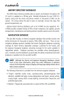
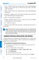
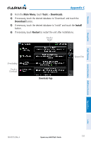
Overview Navigation Appendix C • *VORs-identifier, facility name, city/state/country, location (latitude/longitude), frequency, service volume (high, low, terminal), and type (such as VOR-DME, TACAN, and VORTAC). • *NDBs-identifier, facility name, city/state/country, location (latitude/longitude), and frequency. • Intersections-identifier, nearest VOR, radial and distance from nearest VOR, location (latitude/longitude), and region/country. • ARTCC-Air Route Traffic Control Centers. • Airspace-boundaries (Class B, Class C, Control Zones, SUAs, and MOAs), controlling agency, and vertical boundaries. • FSS-Flight Service Stations. * Symbology used for NDBs, VORs, and airports is consistent with those used on a sectional chart. Additional Features Hazard Avoidance Flight Planning NOTE: After performing a navigation database update, verify all flight plan(s) (routes) are current. If there is an obsolete aviation point in a saved route, the route is locked and unusable. A new route with current navigation database points will need to be created. DATABASE PURCHASE, INSTALLATION, AND UPDATES Database purchases are available online (www.fly.garmin.com). However, once the databases are purchased online, the ability to download and install databases is available from the aera 660 via WiFi. Purchasing/downloading/installing databases: 1) If necessary, from www.fly.garmin.com register the unit and purchase the desired databases. 2) Connect to a WiFi network on the aera 660: a) From the Main Menu, touch Tools > Setup > Wi-Fi > On. b) Touch Add Network. c) Touch the desired network to add. d) If necessary, enter the password using the keypad and touch Enter. Appendices Index 130 Garmin aera 660 Pilot's Guide 190-02017-20 Rev. A
-
 1
1 -
2
-
3
-
4
-
5
-
6
-
7
-
8
-
9
-
10
-
11
-
12
-
13
-
14
-
15
-
16
-
17
-
18
-
19
-
20
-
21
-
22
-
23
-
24
-
25
-
26
-
27
-
28
-
29
-
30
-
31
-
32
-
33
-
34
-
35
-
36
-
37
-
38
-
39
-
40
-
41
-
42
-
43
-
44
-
45
-
46
-
47
-
48
-
49
-
50
-
51
-
52
-
53
-
54
-
55
-
56
-
57
-
58
-
59
-
60
-
61
-
62
-
63
-
64
-
65
-
66
-
67
-
68
-
69
-
70
-
71
-
72
-
73
-
74
-
75
-
76
-
77
-
78
-
79
-
80
-
81
-
82
-
83
-
84
-
85
-
86
-
87
-
88
-
89
-
90
-
91
-
92
-
93
-
94
-
95
-
96
-
97
-
98
-
99
-
100
-
101
-
102
-
103
-
104
-
105
-
106
-
107
-
108
-
109
-
110
-
111
-
112
-
113
-
114
-
115
-
116
-
117
-
118
-
119
-
120
-
121
-
122
-
123
-
124
-
125
-
126
-
127
-
128
-
129
-
130
-
131
-
132
-
133
-
134
-
135
-
136
-
137
-
138
-
139
-
140
-
 141
141 -
 142
142 -
 143
143 -
 144
144 -
 145
145 -
 146
146 -
 147
147 -
 148
148 -
 149
149 -
 150
150 -
 151
151 -
152
-
153
-
154
-
155
-
156
-
157
-
158
-
159
-
160
-
161
-
162
-
163
-
164
-
165
-
166
-
167
-
168
-
169
-
170
-
171
-
172
-
173
-
174
-
175
-
176
-
177
-
178
-
179
-
180
-
181
-
182
-
183
-
184
-
185
-
186
-
187
-
188
-
189
-
190
-
191
-
192
-
193
-
194
-
195
-
196
-
197
-
198
-
199
-
200
-
201
-
202
-
203
-
204
 |
 |