Garmin aera 660 aera 660 Pilot s Guide - Page 107
USING FIS-B WEATHER PRODUCTS, Viewing FIS-B Weather products on the Navigation Map
 |
View all Garmin aera 660 manuals
Add to My Manuals
Save this manual to your list of manuals |
Page 107 highlights
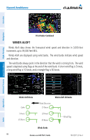
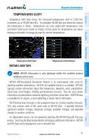
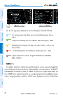
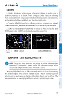
Overview Navigation Flight Planning Hazard Avoidance Additional Features USING FIS-B WEATHER PRODUCTS Hazard Avoidance WARNING: Do not use data link weather information for maneuvering in, near, or around areas of hazardous weather. Information contained within data link weather products may not accurately depict current weather conditions. WARNING: Do not use the indicated data link weather product age to determine the age of the weather information shown by the datalink weather product. Due to time delays inherent in gathering and processing weather data for data link transmission, the weather information shown by the data link weather product may be significantly older than the indicated weather product age. FIS-B Weather Products can be displayed on the Map Page and individually on the Weather (WX) Page. The setup menu for the Map Page controls the map range settings above which weather products are decluttered from the display. If a map range larger than the weather product map range setting is selected, the weather product data is removed from the map. The menu also provides a means for enabling/disabling display of 'Airmets', 'Sigmets', 'Weather Data', and/or 'NEXRAD' on the Map Page. Additional information about the following can be displayed by panning over the display on the Weather Page or the Map Page: • SIGMETs • METARs • AIRMETs • TFRs Additional information is also available for PIREPs on the Weather Page (not displayed on the Map Page): Viewing FIS-B Weather products on the Navigation Map: 1) From the Main Menu, touch Map. 2) Touch Menu. 3) Touch Weather. Appendices Index 190-02017-20 Rev. A Garmin aera 660 Pilot's Guide 91
-
 1
1 -
2
-
3
-
4
-
5
-
6
-
7
-
8
-
9
-
10
-
11
-
12
-
13
-
14
-
15
-
16
-
17
-
18
-
19
-
20
-
21
-
22
-
23
-
24
-
25
-
26
-
27
-
28
-
29
-
30
-
31
-
32
-
33
-
34
-
35
-
36
-
37
-
38
-
39
-
40
-
41
-
42
-
43
-
44
-
45
-
46
-
47
-
48
-
49
-
50
-
51
-
52
-
53
-
54
-
55
-
56
-
57
-
58
-
59
-
60
-
61
-
62
-
63
-
64
-
65
-
66
-
67
-
68
-
69
-
70
-
71
-
72
-
73
-
74
-
75
-
76
-
77
-
78
-
79
-
80
-
81
-
82
-
83
-
84
-
85
-
86
-
87
-
88
-
89
-
90
-
91
-
92
-
93
-
94
-
95
-
96
-
97
-
98
-
99
-
100
-
101
-
 102
102 -
 103
103 -
 104
104 -
 105
105 -
 106
106 -
 107
107 -
 108
108 -
 109
109 -
 110
110 -
 111
111 -
 112
112 -
113
-
114
-
115
-
116
-
117
-
118
-
119
-
120
-
121
-
122
-
123
-
124
-
125
-
126
-
127
-
128
-
129
-
130
-
131
-
132
-
133
-
134
-
135
-
136
-
137
-
138
-
139
-
140
-
141
-
142
-
143
-
144
-
145
-
146
-
147
-
148
-
149
-
150
-
151
-
152
-
153
-
154
-
155
-
156
-
157
-
158
-
159
-
160
-
161
-
162
-
163
-
164
-
165
-
166
-
167
-
168
-
169
-
170
-
171
-
172
-
173
-
174
-
175
-
176
-
177
-
178
-
179
-
180
-
181
-
182
-
183
-
184
-
185
-
186
-
187
-
188
-
189
-
190
-
191
-
192
-
193
-
194
-
195
-
196
-
197
-
198
-
199
-
200
-
201
-
202
-
203
-
204
 |
 |
