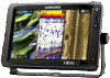
Lowrance HDS-12 Gen2 Touch Operation Manual - Page 24
Chart options
 |
View all Lowrance HDS-12 Gen2 Touch manuals
Add to My Manuals
Save this manual to your list of manuals |
Page 24 highlights
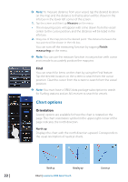
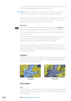
¼¼ Note: To measure distance from your vessel, tap the desired location on the map and the distance to that location will be shown in the info box in the lower left corner of the screen. 1. Tap the screen and then tap Measure on the menu • The measuring icons will appear with a line drawn from the vessel center to the cursor position, and the distance will be listed in the info box. 2. Drag one of the map pins to the desired point. The distance between the two points will be shown in the info box. You can turn off the measuring function by tapping Finish measuring on the menu. ¼¼ Note: You can use the measure function in conjunction with cursor assist mode to accurately position the map pins. Find You can search for items on the chart by using the Find feature. Tap the desired location on the screen to search from the cursor position. Clear the cursor from the screen to search from the vessel position. ¼¼ Note: You must have a SIRIUS data package subscription to search for Fueling stations and an AIS receiver to search for vessels. Chart options Orientation Several options are available for how the chart is rotated on the page. The chart orientation symbol in the upper right corner of the page indicates the north direction. North up Displays the chart with the north direction upward. Corresponds to the usual orientation of nautical charts. 22 | North up Heading up Chart | Lowrance HDS Gen2 Touch Course up
-
 1
1 -
2
-
3
-
4
-
5
-
6
-
7
-
8
-
9
-
10
-
11
-
12
-
13
-
14
-
15
-
16
-
17
-
18
-
 19
19 -
 20
20 -
 21
21 -
 22
22 -
 23
23 -
 24
24 -
 25
25 -
 26
26 -
 27
27 -
 28
28 -
 29
29 -
30
-
31
-
32
-
33
-
34
-
35
-
36
-
37
-
38
-
39
-
40
-
41
-
42
-
43
-
44
-
45
-
46
-
47
-
48
-
49
-
50
-
51
-
52
-
53
-
54
-
55
-
56
-
57
-
58
-
59
-
60
-
61
-
62
-
63
-
64
-
65
-
66
-
67
-
68
-
69
-
70
-
71
-
72
-
73
-
74
-
75
-
76
-
77
-
78
-
79
-
80
-
81
-
82
-
83
-
84
-
85
-
86
-
87
-
88
-
89
-
90
-
91
-
92
-
93
-
94
-
95
-
96
-
97
-
98
-
99
-
100
-
101
-
102
-
103
-
104
-
105
-
106
-
107
-
108
-
109
-
110
-
111
-
112
-
113
-
114
-
115
-
116
-
117
-
118
-
119
-
120
-
121
-
122
-
123
-
124
-
125
-
126
-
127
-
128
-
129
-
130
-
131
-
132
-
133
-
134
-
135
-
136
-
137
 |
 |
