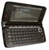
Nokia E90 User Guide - Page 55
Extra services for Maps, GPS data
 |
UPC - 890552609147
View all Nokia E90 manuals
Add to My Manuals
Save this manual to your list of manuals |
Page 55 highlights
Global Positioning System (GPS) 4. To view the route itinerary, select Options > Show route. The route is calculated using the selected routing settings. To view the itinerary route on the map, select Options > Show on map. To run a simulation of the route, select Options > Start simulation. Tip: You can also use a compatible GPS receiver with Bluetooth connectivity with Maps. For example, in a car, an external GPS receiver can be positioned so that it has a clear view of the sky. Enable the use of an external GPS receiver in the positioning settings. Extra services for Maps You can purchase a turn-by-turn navigation service with voice guidance to use in Maps. You can also purchase and download different kinds of guides, such as city and travel guides, for different cities. The downloaded guides are automatically saved to your device. The licence you purchase for a guide or navigation is device-specific and cannot be transferred from your device to another device. Navigation To purchase a navigation service with voice guidance, select Options > Extra services > Add navigation. After creating a route in Maps, to start navigation to the desired destination with GPS using voice guidance, select Options > Start navigation. You can also start navigation by selecting any location on the map or in a results list, and Navigate to. When you use navigation for the first time, you are prompted to select the language of the voice guidance and download the voice guidance files of the selected language. You can also download voice guidance files using Nokia Map Loader. To change the language later, in the Maps main view, select Options > Settings > General > Voice guidance. To discard the created route and use another route, select Options > Alternative route. To view only the next turns and hide the map, select Options > Map options > Arrow mode. To stop navigation, select Options > Stop navigation. Guides To purchase and download guides, select Options > Extra services > Guides. The guides provide information about attractions, restaurants, hotels, and other points of interest. The guides must be downloaded and purchased before use. To download a new guide to your device, scroll to the nearest guides or all guides tab, select the desired guide, and OK. The purchase process starts automatically. You can pay for the guides through a credit card or have the amount charged to your phone bill, if supported by your cellular network service provider. To confirm the purchase, select OK twice. To receive a confirmation of the purchase through e-mail, enter your name and e-mail address, and select OK. To browse a downloaded guide, scroll to the my guides tab, select a guide and a subcategory, if available. GPS data This feature is not designed to support positioning requests for related calls. Contact your service provider for more information about how your phone complies with government regulations on location based emergency calling services. GPS should only be used as a navigation aid. It should not be used for precise location measurement and you should never rely solely on location data from the GPS receiver for positioning or navigation. Select > GPS > GPS data. With GPS data, you can view your current location, find your way to a desired location, and track distance. Select Navigation to view navigating information to your trip destination, Position to view positioning information about your current location, or Trip dist. to view your traveling information such as the distance and duration you have traveled, and your average and maximum speeds. The application must receive positioning information from at least three satellites to be used as a traveling aid. To select a positioning method to detect the location of your device, select Options > Positioning settings, scroll to the desired positioning method, and select Options > Enable. To check the signal strength of the satellites that provide the positioning information necessary for navigation, open any of the three views and select Options > Satellite status. To set a landmark or location as the destination of your trip, select Navigation > Options > Set destination. You can also enter the destination latitude and longitude coordinates. To remove the destination set for your trip, select Navigation > Options > Stop navigation. To save your current position as a landmark, select Navigation or Position, and Options > Save position. © 2007 Nokia. All rights reserved. 55
-
 1
1 -
2
-
3
-
4
-
5
-
6
-
7
-
8
-
9
-
10
-
11
-
12
-
13
-
14
-
15
-
16
-
17
-
18
-
19
-
20
-
21
-
22
-
23
-
24
-
25
-
26
-
27
-
28
-
29
-
30
-
31
-
32
-
33
-
34
-
35
-
36
-
37
-
38
-
39
-
40
-
41
-
42
-
43
-
44
-
45
-
46
-
47
-
48
-
49
-
 50
50 -
 51
51 -
 52
52 -
 53
53 -
 54
54 -
 55
55 -
 56
56 -
 57
57 -
 58
58 -
 59
59 -
 60
60 -
61
-
62
-
63
-
64
-
65
-
66
-
67
-
68
-
69
-
70
-
71
-
72
-
73
-
74
-
75
-
76
-
77
-
78
-
79
-
80
-
81
-
82
-
83
-
84
-
85
-
86
-
87
-
88
-
89
-
90
-
91
-
92
-
93
 |
 |