Sony NV-U73T Instruction Manual - Page 26
Map settings, Route profile settings, Guidance settings, Always Show Traffic Button - driver
 |
UPC - 027242728523
View all Sony NV-U73T manuals
Add to My Manuals
Save this manual to your list of manuals |
Page 26 highlights
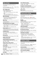
Map settings The following map display settings are configurable. In the menu display, touch c "Map" c the desired item c the desired option. 2D / 3D Map View To select the default map view. - "2D": Overhead view. - "3D" (level 1): Overhead view from a slight angle. - "3D" (level 2): Elevated view. - "3D" (level 3): Driver's view, with horizon. Map Orientation To select the default orientation of 2D map. - "In Direction of Travel": Heading up. - "Always North": North up. Map Color To select the map color schemes for day time use and night time use. Automatic Map Color Change To switch the map color scheme automatically. - "ON": Switches automatically depending on the time of day. - "OFF": Always sets to day time colors. Preset Scale (page 6) To preset the map scale level for clockwise and counterclockwise circles of Gesture Command. Landmark Icon To show landmark icons on the map. The settings can be configured separately for each facility. Driving Trail To show driving trail on the map: "ON," "OFF." Delete Driving Trail To delete driving trail. Display Address Book Entries To show the address book entry icons on the map: "ON," "OFF." Always Show Traffic Button To always show the traffic icon on the map: "ON," "OFF." Road Width To select the width of the road shown on the map: "Wide," "Standard." Font Size To select the size of the fonts shown on the map: "Large," "Medium," "Small." Icon Size To select the size of the icons shown on the map: 26 "Large," "Medium," "Small." Zoom While Scrolling To zoom out the map/fixes the scale when scrolling: "ON," "OFF." Compass and Speedometer To show the current speed and direction on the map when no route guidance is in progress: "ON," "OFF." Map Version To view the version of the current map. Route profile settings The following route profile settings are configurable. In the menu display, touch c "Route Profile" c the desired item c the desired option. Ferries Carpool Lanes To set the preference for using ferries or carpool lanes when calculating a route. - "Allow": Allows the use. - "Avoid": Allows the use only when no alternative is available. Traffic Information To calculate an alternative route when traffic messages are received: "Use," "Not Use." Driving Route History To use the driving route history when calculating the route: "Use," "Not Use." Calculation Condition To set the route calculation conditions. - "Standard": Sets a recommended route. - "Avoid Toll Roads": Avoids the use of toll roads. - "Avoid Toll Roads (Shortest)": Sets a distance- optimized route without toll roads. Guidance settings The following route guidance settings are configurable. In the menu display, touch c "Guide" c the desired item c the desired option. Volume (Guide) To preset the volume level for voice guidance: "Level 3," "Level 2," "Level 1," "OFF." Voice Attention (Merge) To activate the audio warning on merge: "ON," "OFF."
-
 1
1 -
2
-
3
-
4
-
5
-
6
-
7
-
8
-
9
-
10
-
11
-
12
-
13
-
14
-
15
-
16
-
17
-
18
-
19
-
20
-
 21
21 -
 22
22 -
 23
23 -
 24
24 -
 25
25 -
 26
26 -
 27
27 -
 28
28 -
 29
29 -
 30
30 -
 31
31
 |
 |