Garmin ECHOMAP Plus 42cv Owners Manual PDF - Page 18
Garmin Quickdraw Contours Settings, Basic Navigation Questions
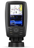 |
View all Garmin ECHOMAP Plus 42cv manuals
Add to My Manuals
Save this manual to your list of manuals |
Page 18 highlights
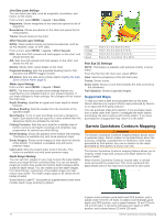
If your device does not have Wi‑Fi technology, you can access the Garmin Quickdraw Community using the Garmin Connect website. If your device has Wi‑Fi technology, you should access the Garmin Quickdraw Community using the ActiveCaptain app (Connecting to the Garmin Quickdraw Community with ActiveCaptain, page 11). 1 Insert the memory card into your computer. 2 Access the Garmin Quickdraw Community (Connecting to the Garmin Quickdraw Community with Garmin Connect, page 11). 3 Select Search for Contours. 4 Use the map and search features to locate an area to download. The red dots represent Garmin Quickdraw Contours maps that have been shared for that region. 5 Select Select an Area to Download. 6 Drag the edges of the box to select the area to download. 7 Select Start Download. 8 Save the file to your memory card. TIP: If you cannot find the file, look in the "Downloads" folder. The browser may have saved the file there. 9 Remove the memory card from your computer. 10Insert the memory card into the card slot (Inserting Memory Cards, page 2). The chartplotter automatically recognizes the contours maps. The chartplotter may take a few minutes to load the maps. Garmin Quickdraw Contours Settings From a chart, select MENU > Quickdraw Contours > Settings. Recording Offset: Sets the distance between the sonar depth and the contour recording depth. If the water level has changed since your last recording, adjust this setting so the recording depth is the same for both recordings. For example, if the last time you recorded had a sonar depth of 3.1 m (10.5 ft.), and today's sonar depth is 3.6 m (12 ft.), enter -0.5 m (-1.5 ft.) for the a Recording Offset value. User Display Offset: Sets differences in contour depths and depth labels on your own contours maps to compensate for changes in the water level of a body of water, or for depth errors in recorded maps. Comm. Display Offset: Sets differences in contour depths and depth labels on the community contours maps to compensate for changes in the water level of a body of water, or for depth errors in recorded maps. Survey Coloring: Sets the color of the Garmin Quickdraw Contours display. When this setting is turned on, the colors indicate the quality of the recording. When this setting is turned off, the contour areas use standard map colors. Green indicates good depth and GPS position, and a speed under 16 km/h (10 mph). Yellow indicates good depth and GPS position, and a speed between 16 and 32 km/h (10 and 20 mph). Red indicates poor depth or GPS position, and a speed above 32 km/h (20 mph). Navigation with a Chartplotter WARNING All route and navigation lines displayed on the chartplotter are only intended to provide general route guidance or to identify proper channels, and are not intended to be precisely followed. Always defer to the navaids and conditions on the water when navigating to avoid groundings or hazards that could result in vessel damage, personal injury, or death. The Auto Guidance feature is based on electronic chart information. That data does not ensure obstacle and bottom clearance. Carefully compare the course to all visual sightings, and avoid any land, shallow water, or other obstacles that may be in your path. When using Go To, a direct course and a corrected course may pass over land or shallow water. Use visual sightings, and steer to avoid land, shallow water, and other dangerous objects. CAUTION If your vessel has an autopilot system, a dedicated autopilot control display must be installed at each steering helm in order to disable the autopilot system. NOTE: Some chart views are available with premium charts, in some areas. To navigate, you must choose a destination, set a course or create a route, and follow the course or route. You can follow the course or the route on the Navigation chart, Fishing chart, Perspective 3D chart view, or Mariner's Eye 3D chart view. You can set and follow a course to a destination using one of three methods: Go To, Route To, or Auto Guidance. Go To: Takes you directly to the destination. This is the standard option for navigating to a destination. The chartplotter creates a straight-line course or navigation line to the destination. The path may run over land and other obstacles. Route To: Creates a route from your location to a destination, allowing you to add turns along the way. This option provides a straight-line course to the destination, but allows you to add turns into the route to avoid land and other obstacles. Auto Guidance: Uses the specified information about your vessel and chart data to determine the best path to your destination. This option is available only when using a compatible premium chart in a compatible chartplotter. It provides a turn-by-turn navigation path to the destination, avoiding land and other obstacles (Auto Guidance, page 15). When you are using a compatible Garmin autopilot connected to the chartplotter using NMEA 2000®, the autopilot follows the Auto Guidance route. NOTE: Auto Guidance is available with premium charts, in some areas. Basic Navigation Questions Question Answer How do I make the chartplotter Navigate using Go To (Setting and point me in the direction in Following a Direct Course Using Go which I want to go (bearing)? To, page 13). How do I make the device guide me along a straight line (minimizing cross track) to a location using the shortest distance from the present location? Build a single-leg route and navigate it using Route To (Creating and Navigating a Route From Your Present Location, page 14). How do I make the device guide me to a location while avoiding charted obstacles? Build a multi-leg route and navigate it using Route To (Creating and Navigating a Route From Your Present Location, page 14). How do I make the device steer Navigate using Route To (Creating my automatic pilot? and Navigating a Route From Your Present Location, page 14). 12 Navigation with a Chartplotter
-
 1
1 -
2
-
3
-
4
-
5
-
6
-
7
-
8
-
9
-
10
-
11
-
12
-
 13
13 -
 14
14 -
 15
15 -
 16
16 -
 17
17 -
 18
18 -
 19
19 -
 20
20 -
 21
21 -
 22
22 -
 23
23 -
24
-
25
-
26
-
27
-
28
-
29
-
30
-
31
-
32
-
33
-
34
-
35
-
36
-
37
-
38
-
39
-
40
-
41
-
42
-
43
-
44
-
45
-
46
-
47
-
48
-
49
-
50
-
51
-
52
-
53
-
54
 |
 |
