Kenwood DNX573S Navigation - Page 15
Viewing Route Activity - reset button
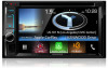 |
View all Kenwood DNX573S manuals
Add to My Manuals
Save this manual to your list of manuals |
Page 15 highlights
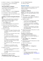
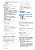
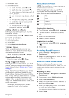
Changing the Map Data Field 1 From the map, select the data field in the lower left-hand corner. 2 Select a type of data to display. 3 Select Save. Customizing Map Buttons You can include up to three icons on the right side of the main map. 1 Select Settings > Map & Vehicle > Map Buttons. 2 Select an icon, and select OK. 3 Select . 4 Select a different icon. 5 Select Save. Removing Buttons from the Map You can remove all buttons from the right side of the map. 1 Select Settings > Map & Vehicle > Map Buttons. 2 Select an icon, and select OK. 3 Select Save. Changing the Map Perspective 1 Select Settings > Map & Vehicle > Driving Map View. 2 Select an option: • Select Track Up to display the map in two dimensions (2-D), with your direction of travel at the top. • Select North Up to display the map in 2-D with north at the top. • Select 3-D to display the map in three dimensions. 3 Select Save. Viewing Route Activity Viewing a List of Turns While navigating a route, you can view all of the turns and maneuvers for your entire route and the distance between turns. 1 While navigating a route, select the text bar on the top of the map. 2 Select a turn. The details for the turn appear. If available, an image of the junction appears for junctions on major roadways. Viewing the Entire Route on the Map 1 While navigating a route, select the navigation bar at the top of the map. 2 Select > Map. Viewing the Next Turn While navigating a route, a preview of the next turn, lane change, or other maneuver appears in the upper-left corner of the map. The preview includes the distance to the turn or maneuver and the lane in which you should be traveling, if available. From the map, select turn on the map. to view the next Viewing Traffic Alerts While navigating a route, a traffic alert may appear in the navigation bar. Select the alert to view more information. Viewing Junctions While navigating a route, you can view the junctions on major roadways. When you approach a junction in a route, the image of that junction appears briefly, if available. NOTE: This feature is not available on all models. From the map, select junction, if available. to view the Viewing the Trip Information Page The trip information page displays your speed and provides statistics about your trip. NOTE: If you make frequent stops, leave the device turned on, so it can accurately measure elapsed time during the trip. From the map, select Speed. Resetting Trip Information 1 From the map, select Speed. 2 Select > Reset All. 3 Select an option: • When not navigating a route, select Select All to reset every data field except the speedometer, on the first page. • Select Reset Trip Data to reset the information on the trip computer. • Select Reset Trip B to reset the odometer. Map Pages 7
-
 1
1 -
2
-
3
-
4
-
5
-
6
-
7
-
8
-
9
-
 10
10 -
 11
11 -
 12
12 -
 13
13 -
 14
14 -
 15
15 -
 16
16 -
 17
17 -
 18
18 -
 19
19 -
 20
20 -
21
-
22
 |
 |
