Lowrance HOOK Reveal 7 SplitShot HOOK Reveal Series Operator Manual - Page 24
Selecting chart type, Vessel symbol, Chart scale, Panning the chart, Waypoints, Routes, and Trails
 |
View all Lowrance HOOK Reveal 7 SplitShot manuals
Add to My Manuals
Save this manual to your list of manuals |
Page 24 highlights
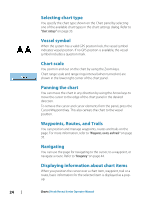
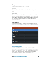
Selecting chart type You specify the chart type shown on the Chart panel by selecting one of the available chart types in the chart settings dialog. Refer to "Chart settings" on page 33. Vessel symbol When the system has a valid GPS position lock, the vessel symbol indicates vessel position. If no GPS position is available, the vessel symbol includes a question mark. Chart scale You zoom in and out on the chart by using the Zoom keys. Chart range scale and range rings interval (when turned on) are shown in the lower right corner of the chart panel. Panning the chart You can move the chart in any direction by using the Arrow keys to move the cursor to the edge of the chart panel in the desired direction. To remove the cursor and cursor elements from the panel, press the Cursor/Waypoint key. This also centers the chart to the vessel position. Waypoints, Routes, and Trails You can position and manage waypoints, routes and trails on the page. For more information, refer to "Waypoints, routes, and trails" on page 35. Navigating You can use the page for navigating to the cursor, to a waypoint, or navigate a route. Refer to "Navigating" on page 44. Displaying information about chart items When you position the cursor over a chart item, waypoint, trail or a route, basic information for the selected item is displayed as a popup. 24 Charts | Hook Reveal Series Operator Manual
-
 1
1 -
2
-
3
-
4
-
5
-
6
-
7
-
8
-
9
-
10
-
11
-
12
-
13
-
14
-
15
-
16
-
17
-
18
-
 19
19 -
 20
20 -
 21
21 -
 22
22 -
 23
23 -
 24
24 -
 25
25 -
 26
26 -
 27
27 -
 28
28 -
 29
29 -
30
-
31
-
32
-
33
-
34
-
35
-
36
-
37
-
38
-
39
-
40
-
41
-
42
-
43
-
44
-
45
-
46
-
47
-
48
-
49
-
50
-
51
-
52
-
53
-
54
-
55
-
56
-
57
-
58
-
59
-
60
-
61
-
62
-
63
-
64
-
65
-
66
-
67
-
68
-
69
-
70
-
71
-
72
-
73
-
74
-
75
-
76
-
77
-
78
-
79
-
80
-
81
-
82
-
83
-
84
-
85
-
86
 |
 |
