Lowrance HOOK Reveal 7 SplitShot HOOK Reveal Series Operator Manual - Page 34
Pop-up information, Range rings, Grid lines, Waypoints, Routes, Trails, Course extension line
 |
View all Lowrance HOOK Reveal 7 SplitShot manuals
Add to My Manuals
Save this manual to your list of manuals |
Page 34 highlights
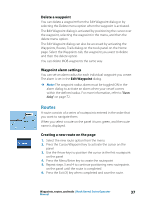
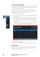
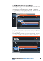
Pop-up information Determines whether basic information for panel items is displayed when you select the item. Range rings The range rings can be used to present the distance from your vessel to other panel objects. The range scale is set automatically by the system to suit the panel scale. Grid lines Turns on/off viewing of longitude and latitude grid lines on the panel. Waypoints, Routes, Trails Turns on/off displaying these items on panels. Course extension line Turns on/off displaying the Course Over Ground (COG) extension line on the panel. The COG is based on information from the GPS. Extension line length When the course extension option is turned on, specify the length of the line to be displayed. SonarChart Live tide correction When selected, the tide correction feature uses information from nearby tide stations (if available) to adjust the depth values used by SonarChart Live as the sonar is recorded. 34 Charts | Hook Reveal Series Operator Manual
-
 1
1 -
2
-
3
-
4
-
5
-
6
-
7
-
8
-
9
-
10
-
11
-
12
-
13
-
14
-
15
-
16
-
17
-
18
-
19
-
20
-
21
-
22
-
23
-
24
-
25
-
26
-
27
-
28
-
 29
29 -
 30
30 -
 31
31 -
 32
32 -
 33
33 -
 34
34 -
 35
35 -
 36
36 -
 37
37 -
 38
38 -
 39
39 -
40
-
41
-
42
-
43
-
44
-
45
-
46
-
47
-
48
-
49
-
50
-
51
-
52
-
53
-
54
-
55
-
56
-
57
-
58
-
59
-
60
-
61
-
62
-
63
-
64
-
65
-
66
-
67
-
68
-
69
-
70
-
71
-
72
-
73
-
74
-
75
-
76
-
77
-
78
-
79
-
80
-
81
-
82
-
83
-
84
-
85
-
86
 |
 |
