Nokia 002L5G7 User Guide - Page 94
Check the satellite signal status, Applications, Location, GPS data, Position, Options
 |
View all Nokia 002L5G7 manuals
Add to My Manuals
Save this manual to your list of manuals |
Page 94 highlights
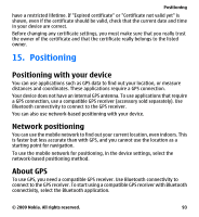
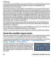
Positioning The coordinates in the GPS are expressed in the degrees and decimal degrees format using the international WGS-84 coordinate system. The availability of the coordinates may vary by region. The Global Positioning System (GPS) is operated by the government of the United States, which is solely responsible for its accuracy and maintenance. The accuracy of location data can be affected by adjustments to GPS satellites made by the United States government and is subject to change with the United States Department of Defense civil GPS policy and the Federal Radionavigation Plan. Accuracy can also be affected by poor satellite geometry. Availability and quality of GPS signals may be affected by your location, buildings, natural obstacles, and weather conditions. GPS signals may not be available inside buildings or underground and may be impaired by materials such as concrete and metal. GPS should not be used for precise location measurement, and you should never rely solely on location data from the GPS receiver and cellular radio networks for positioning or navigation. The trip meter has limited accuracy, and rounding errors may occur. Accuracy can also be affected by availability and quality of GPS signals. Different positioning methods can be enabled or disabled in positioning settings. Check the satellite signal status Your device does not have an internal GPS antenna. To use applications that require a GPS connection, use a compatible GPS receiver (accessory sold separately). To check how many satellites the GPS receiver has found, and whether it is receiving satellite signals, select Menu > Applications > Location and GPS data > Position > Options > Satellite status. If the GPS receiver has found satellites, a bar for each satellite is displayed in the satellite information view. The longer the bar, the stronger the satellite signal. When the GPS receiver has received enough data from the satellite signal to calculate your location, the bar turns blue. 94 © 2009 Nokia. All rights reserved.
-
 1
1 -
2
-
3
-
4
-
5
-
6
-
7
-
8
-
9
-
10
-
11
-
12
-
13
-
14
-
15
-
16
-
17
-
18
-
19
-
20
-
21
-
22
-
23
-
24
-
25
-
26
-
27
-
28
-
29
-
30
-
31
-
32
-
33
-
34
-
35
-
36
-
37
-
38
-
39
-
40
-
41
-
42
-
43
-
44
-
45
-
46
-
47
-
48
-
49
-
50
-
51
-
52
-
53
-
54
-
55
-
56
-
57
-
58
-
59
-
60
-
61
-
62
-
63
-
64
-
65
-
66
-
67
-
68
-
69
-
70
-
71
-
72
-
73
-
74
-
75
-
76
-
77
-
78
-
79
-
80
-
81
-
82
-
83
-
84
-
85
-
86
-
87
-
88
-
 89
89 -
 90
90 -
 91
91 -
 92
92 -
 93
93 -
 94
94 -
 95
95 -
 96
96 -
 97
97 -
 98
98 -
 99
99 -
100
-
101
-
102
-
103
-
104
-
105
-
106
-
107
-
108
-
109
-
110
-
111
-
112
-
113
-
114
-
115
-
116
-
117
-
118
-
119
-
120
-
121
-
122
-
123
-
124
-
125
-
126
-
127
-
128
-
129
-
130
-
131
-
132
-
133
-
134
-
135
-
136
-
137
-
138
-
139
-
140
-
141
-
142
-
143
-
144
-
145
-
146
-
147
-
148
-
149
-
150
-
151
-
152
-
153
-
154
-
155
-
156
-
157
-
158
-
159
 |
 |
