Garmin Astro 220 Owner's Manual - Page 53
Map Setup - General Orientation, Below, Auto Zoom, Detail, Lock On Road, Saved Tracks, Track Log
 |
UPC - 753759063931
View all Garmin Astro 220 manuals
Add to My Manuals
Save this manual to your list of manuals |
Page 53 highlights
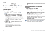
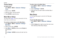
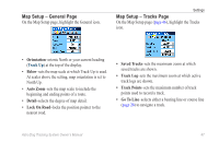
Map Setup - General Page On the Map Setup page, highlight the General icon. Settings Map Setup - Tracks Page On the Map Setup page (page 46), highlight the Tracks icon. • Orientation-orients North or your current heading (Track Up) at the top of the display. • Below-sets the map scale at which Track Up is used. At scales above the setting, map orientation is set to North Up. • Auto Zoom-sets the map scale to include the beginning and ending points of a route. • Detail-selects the degree of map detail. • Lock On Road-locks the position pointer to the nearest road. • Saved Tracks-sets the maximum zoom at which saved tracks are shown. • Track Log-sets the maximum zoom at which active track logs are shown. • Track Points-sets the maximum number of track points used to record a track. • Go To Line-selects either a bearing line or course line (page 26) to navigate a track. Astro Dog Tracking System Owner's Manual 47
-
 1
1 -
2
-
3
-
4
-
5
-
6
-
7
-
8
-
9
-
10
-
11
-
12
-
13
-
14
-
15
-
16
-
17
-
18
-
19
-
20
-
21
-
22
-
23
-
24
-
25
-
26
-
27
-
28
-
29
-
30
-
31
-
32
-
33
-
34
-
35
-
36
-
37
-
38
-
39
-
40
-
41
-
42
-
43
-
44
-
45
-
46
-
47
-
 48
48 -
 49
49 -
 50
50 -
 51
51 -
 52
52 -
 53
53 -
 54
54 -
 55
55 -
 56
56 -
 57
57 -
 58
58 -
59
-
60
-
61
-
62
-
63
-
64
-
65
-
66
-
67
-
68
-
69
-
70
-
71
-
72
-
73
-
74
-
75
-
76
 |
 |
