Garmin Astro 220 Owner's Manual - Page 61
Accuracy, Miscellaneous, Power, Radio, Velocity, Compass, Altimeter, Interfaces, Data Storage Life - map card
 |
UPC - 753759063931
View all Garmin Astro 220 manuals
Add to My Manuals
Save this manual to your list of manuals |
Page 61 highlights
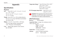
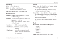
Accuracy GPS: < 33 ft. (10 m) 95% DGPS: 10-16 ft. (3-5 m) 95% typical (WAAS accuracy in North America) Velocity: 0.164 ft./sec. (0.05 m/sec) steady state Miscellaneous Compass: Accuracy (when calibrated); ± 2 degrees, resolution; 1 degree Altimeter: Accuracy (when calibrated): ± 10 ft. (3 m) Resolution: 1 ft. (0.3 m) Range: from -2,000 ft. to 30,000 ft. (from -610 to 9144 m) Interfaces: USB for computer interface Data Storage Life:Indefinite; no memory battery required Map Storage: microSD card capacity (a small portion of the card capacity is used for formatting) Appendix Power Source: Astro 220: Two 1.5 volt AA batteries, vehicle power adapter, USB data cable DC 30: Internal rechargeable lithium-ion battery, vehicle power adapter, AC charger Battery Life: Astro 220: Up to 24 hours (typical use). Alkaline batteries lose capacity as temperature decreases. Use lithium batteries when operating in below-freezing conditions. DC 30: from 17 to 36 hours. Recharging takes 4½ hours. Radio MURS (Multi-use Radio Service) Frequency: 151.82 MHz 151.88 MHz 151.94 MHz 154.57 MHz 154.60 MHz Range: Up to 7 miles (11.2 km) - line of sight Astro Dog Tracking System Owner's Manual 55
-
 1
1 -
2
-
3
-
4
-
5
-
6
-
7
-
8
-
9
-
10
-
11
-
12
-
13
-
14
-
15
-
16
-
17
-
18
-
19
-
20
-
21
-
22
-
23
-
24
-
25
-
26
-
27
-
28
-
29
-
30
-
31
-
32
-
33
-
34
-
35
-
36
-
37
-
38
-
39
-
40
-
41
-
42
-
43
-
44
-
45
-
46
-
47
-
48
-
49
-
50
-
51
-
52
-
53
-
54
-
55
-
 56
56 -
 57
57 -
 58
58 -
 59
59 -
 60
60 -
 61
61 -
 62
62 -
 63
63 -
 64
64 -
 65
65 -
 66
66 -
67
-
68
-
69
-
70
-
71
-
72
-
73
-
74
-
75
-
76
 |
 |
