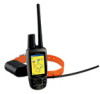
Garmin Astro Astro and DC 30 Owner's Manual - Page 43
Using the Highway Using Proximity Locations, Change Data Fields
 |
UPC - 753759063931
View all Garmin Astro manuals
Add to My Manuals
Save this manual to your list of manuals |
Page 43 highlights
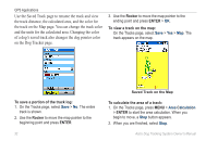
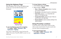
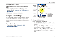
Using the Highway Page When navigating a route on roads, the Highway page provides up to four data fields that display travel information. Highway Page To open the Highway page while navigating: Press MENU > MENU > Advanced > GPS Applications > Highway. Your course is represented by a center line down the middle of the screen. Press IN or OUT to zoom in or out on the map. Astro Dog Tracking System Owner's Manual GPS Applications To change Highway settings: 1. On the Highway page, press MENU. 2. Select an option > ENTER. • Stop (or Resume) Navigation-stops or resumes your current navigation. • Recalculate-recalculates the path to a destination. • Data Fields-selects 2, 3, or 4 data fields that appear on the Highway page. • Change Data Fields-selects the type of data you want to show in the data fields. • Restore Defaults-restores highway settings to the default settings. Using Proximity Locations Use the Proximity Locations page to define an alarm radius around a stored location. An alarm sounds when you enter within the designated radius. To open the Proximity page: Press MENU > MENU > Advanced > GPS Applications > Proximity. 37
-
 1
1 -
2
-
3
-
4
-
5
-
6
-
7
-
8
-
9
-
10
-
11
-
12
-
13
-
14
-
15
-
16
-
17
-
18
-
19
-
20
-
21
-
22
-
23
-
24
-
25
-
26
-
27
-
28
-
29
-
30
-
31
-
32
-
33
-
34
-
35
-
36
-
37
-
 38
38 -
 39
39 -
 40
40 -
 41
41 -
 42
42 -
 43
43 -
 44
44 -
 45
45 -
 46
46 -
 47
47 -
 48
48 -
49
-
50
-
51
-
52
-
53
-
54
-
55
-
56
-
57
-
58
-
59
-
60
-
61
-
62
-
63
-
64
-
65
-
66
-
67
-
68
-
69
-
70
-
71
-
72
-
73
-
74
-
75
-
76
 |
 |
