Garmin Dakota 10 Owner's Manual - Page 22
Additional Tools, Elevation Plot, Changing the Elevation Plot, Data Fields
 |
UPC - 753759094867
View all Garmin Dakota 10 manuals
Add to My Manuals
Save this manual to your list of manuals |
Page 22 highlights
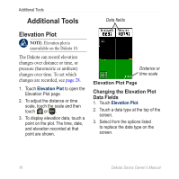
Additional Tools Additional Tools Data fields Elevation Plot note: Elevation plot is unavailable on the Dakota 10. The Dakota can record elevation changes over distance or time, or pressure (barometric or ambient) changes over time. To set which changes are recorded, see page 28. 1. Touch Elevation Plot to open the Elevation Plot page. 2. To adjust the distance or time scale, touch the scale and then touch or . 3. To display elevation data, touch a point on the plot. The time, date, and elevation recorded at that point are shown. Distance or time scale Elevation Plot Page Changing the Elevation Plot Data Fields 1. Touch Elevation Plot. 2. Touch a data type at the top of the screen. 3. Select from the options listed to replace the data type on the screen. 16 Dakota Series Owner's Manual
-
 1
1 -
2
-
3
-
4
-
5
-
6
-
7
-
8
-
9
-
10
-
11
-
12
-
13
-
14
-
15
-
16
-
 17
17 -
 18
18 -
 19
19 -
 20
20 -
 21
21 -
 22
22 -
 23
23 -
 24
24 -
 25
25 -
 26
26 -
 27
27 -
28
-
29
-
30
-
31
-
32
-
33
-
34
-
35
-
36
-
37
-
38
-
39
-
40
-
41
-
42
-
43
-
44
-
45
-
46
-
47
-
48
 |
 |
