Garmin G2000 Cockpit Reference - Page 98
Terrain-SVT, Displaying Terrain-SVT on the Terrain-SVT Display
 |
View all Garmin G2000 manuals
Add to My Manuals
Save this manual to your list of manuals |
Page 98 highlights
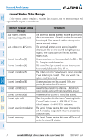
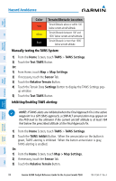
Instruments Flight EIS XPDR/Audio Nav/Com/ AFCS FMS Nav Flight Planning Hazard Avoidance TERRAIN-SVT NOTE: Terrain-SVT is only available when the Synthetic Vision Technology (SVT) option is installed and the TAWS option has not been installed. NOTE: Terrain data is not displayed when the aircraft is outside of the installed terrain database coverage area. Displaying Terrain-SVT on the Terrain-SVT Display: From the Home Screen, touch Terrain SVT. Color Red Yellow Black Terrain/Obstacle Location Terrain/Obstacle above or within 100' below current aircraft altitude. Terrain/Obstacle between 100' and 1000' below current aircraft altitude. Terrain/Obstacle is more than 1000' below aircraft altitude. Enabling/disabling terrain information on the Navigation Map Display: 1) From the Home Screen, touch Map > Map Settings. 2) Touch the Terrain Data Button to display/remove terrain data on the navigation map. When the annunciator on the button is green, the system displays terrain data. When the annunciator is gray, the system removes terrain data from the navigation map. Or: 1) From the Home Screen, touch Map > Map Settings > Map Options. 2) If necessary, touch the Map Tab. 3) Scroll to find the Terrain Data Button. 4) Touch the Terrain Data Button to enable/disable terrain data. Procedures Hazard Avoidance Additional Features Abnormal Operation Annun/ Alerts Appendix Index 82 Garmin G2000 Cockpit Reference Guide for the Cessna Corvalis T240 190-01264-01 Rev. A
-
 1
1 -
2
-
3
-
4
-
5
-
6
-
7
-
8
-
9
-
10
-
11
-
12
-
13
-
14
-
15
-
16
-
17
-
18
-
19
-
20
-
21
-
22
-
23
-
24
-
25
-
26
-
27
-
28
-
29
-
30
-
31
-
32
-
33
-
34
-
35
-
36
-
37
-
38
-
39
-
40
-
41
-
42
-
43
-
44
-
45
-
46
-
47
-
48
-
49
-
50
-
51
-
52
-
53
-
54
-
55
-
56
-
57
-
58
-
59
-
60
-
61
-
62
-
63
-
64
-
65
-
66
-
67
-
68
-
69
-
70
-
71
-
72
-
73
-
74
-
75
-
76
-
77
-
78
-
79
-
80
-
81
-
82
-
83
-
84
-
85
-
86
-
87
-
88
-
89
-
90
-
91
-
92
-
 93
93 -
 94
94 -
 95
95 -
 96
96 -
 97
97 -
 98
98 -
 99
99 -
 100
100 -
 101
101 -
 102
102 -
 103
103 -
104
-
105
-
106
-
107
-
108
-
109
-
110
-
111
-
112
-
113
-
114
-
115
-
116
-
117
-
118
-
119
-
120
-
121
-
122
-
123
-
124
-
125
-
126
-
127
-
128
-
129
-
130
-
131
-
132
-
133
-
134
-
135
-
136
-
137
-
138
-
139
-
140
-
141
-
142
-
143
-
144
-
145
-
146
-
147
-
148
-
149
-
150
-
151
-
152
-
153
-
154
-
155
-
156
-
157
-
158
-
159
-
160
-
161
-
162
-
163
-
164
-
165
-
166
-
167
-
168
-
169
-
170
-
171
-
172
-
173
-
174
-
175
-
176
-
177
-
178
-
179
-
180
-
181
-
182
-
183
-
184
-
185
-
186
-
187
-
188
-
189
-
190
-
191
-
192
-
193
-
194
 |
 |