Garmin G500H G500H Cockpit Reference Guide - Page 26
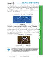
Displaying Garmin Terrain-HSVT, Terrain, Displaying Heading on the Horizon, Displaying Airport Signs
 |
View all Garmin G500H manuals
Add to My Manuals
Save this manual to your list of manuals |
Page 26 highlights
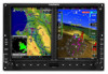
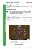
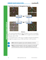
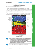
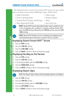
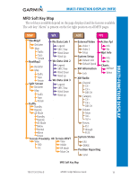
PRIMARY FLIGHT DISPLAY PRIMARY FLIGHT DISPLAY (PFD) The following features are part of the Terrain-HSVT system. For more details refer to the latest revision of the G500H Pilot's Guide, 190-01150-02. • Flight Path Marker • Airport Signs • Horizon Heading Marks • Runway Display • Terrain/Obstacle Display and Alerting • Water • Three-dimensional Traffic • Zero-Pitch Line NOTE: Terrain-HSVT may be deactivated under certain conditions, such as loss of heading. Once condition is resolved, reactivate Terrain-HSVT, press the PFD soft key followed by the SYN VIS soft key, then the SYN TERR soft key. NOTE: Terrain-HSVT features are not a substitute for standard course and altitude deviation information using the CDI, VSI, and VDI. Displaying Garmin Terrain-HSVT™ Terrain 1) Press the PFD soft key. 2) Press the SYN VIS soft key. 3) Press the SYN TERR soft key. 4) Press the BACK soft key to return to the previous page. Displaying Heading on the Horizon 1) Press the PFD soft key. 2) Press the SYN VIS soft key. 3) If not already enabled, press the SYN TERR soft key. 4) Press the HRZN HDG soft key. 5) Press the BACK soft key to return to the previous page. Displaying Airport Signs NOTE: The 'Airport Signs' feature will only display airports, not heliports. 1) Press the PFD soft key. 2) Press the SYN VIS soft key. 3) If not already enabled, press the SYN TERR soft key. 4) Press the APTSIGNS soft key. 5) Press the BACK soft key to return to the previous page. 16 G500H Cockpit Reference Guide 190-01150-03 Rev B
-
 1
1 -
2
-
3
-
4
-
5
-
6
-
7
-
8
-
9
-
10
-
11
-
12
-
13
-
14
-
15
-
16
-
17
-
18
-
19
-
20
-
 21
21 -
 22
22 -
 23
23 -
 24
24 -
 25
25 -
 26
26 -
 27
27 -
 28
28 -
 29
29 -
 30
30 -
 31
31 -
32
-
33
-
34
-
35
-
36
-
37
-
38
-
39
-
40
-
41
-
42
-
43
-
44
-
45
-
46
-
47
-
48
-
49
-
50
-
51
-
52
-
53
-
54
-
55
-
56
-
57
-
58
-
59
-
60
-
61
-
62
-
63
-
64
-
65
-
66
-
67
-
68
-
69
-
70
 |
 |
