Garmin GPS III Plus Owner's Manual - Page 55
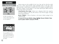
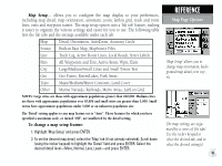
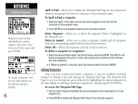
provides visual guidance to the destination waypoint and keeps you on your intended
 |
UPC - 753759015817
View all Garmin GPS III Plus manuals
Add to My Manuals
Save this manual to your list of manuals |
Page 55 highlights
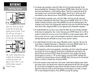
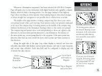
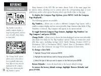
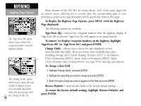
The GPS III+'s Highway Page also provides graphic steering guidance to your destination, by using a graphic highway display. Along the right side of the page (top, when display is vertical) are four user-selectable data fields that display current speed, distance and time to next waypoint, and a bearing pointer (defaults). The bearing pointer always points to the destination waypoint (or the next waypoint when using a route) relative to the direction you are moving (track). If the bearing pointer points straight ahead, you are heading directly to your destination. If the bearing pointer points any direction other than up, turn toward the arrow until it points up-then continue in that direction. Each data field may be configured to display any one of twenty-three data options. The graphic heading compass at the top of the page indicates the direction you are moving (track). Directly below the heading compass, the highway display provides visual guidance to the destination waypoint and keeps you on your intended course line. Your course is represented by the center line down the middle of the graphic highway. As you head toward your destination, the highway perspective will move to indicate your progress to the waypoint and which direction you should steer to stay on course. If you are navigating a route, the highway display will show each route waypoint in sequence, with the route course indicated by a black highway. Nearby waypoints not in the route will also be displayed. You can zoom in or out on the highway display for a smaller or larger view. Five available settings range from 1X to 16X, with a default setting of 8X. To zoom in or out on the highway display: 1. Press the IN zoom key to increase the zoom level and show a smaller view area. 2. Press the OUT zoom key to decrease the zoom level and show a larger view area. REFERENCE Highway Page Your course is represented by the highway center line. Keep the center line in the middle of the display to stay on course. When using a route, the Highway Page will guide you to each waypoint along the route. 45
-
 1
1 -
2
-
3
-
4
-
5
-
6
-
7
-
8
-
9
-
10
-
11
-
12
-
13
-
14
-
15
-
16
-
17
-
18
-
19
-
20
-
21
-
22
-
23
-
24
-
25
-
26
-
27
-
28
-
29
-
30
-
31
-
32
-
33
-
34
-
35
-
36
-
37
-
38
-
39
-
40
-
41
-
42
-
43
-
44
-
45
-
46
-
47
-
48
-
49
-
 50
50 -
 51
51 -
 52
52 -
 53
53 -
 54
54 -
 55
55 -
 56
56 -
 57
57 -
 58
58 -
 59
59 -
 60
60 -
61
-
62
-
63
-
64
-
65
-
66
-
67
-
68
-
69
-
70
-
71
-
72
-
73
-
74
-
75
-
76
-
77
-
78
-
79
-
80
-
81
-
82
-
83
-
84
-
85
-
86
-
87
-
88
-
89
-
90
-
91
-
92
-
93
-
94
-
95
-
96
-
97
-
98
-
99
-
100
-
101
-
102
-
103
-
104
-
105
-
106
-
107
-
108
-
109
-
110
-
111
-
112
-
113
-
114
 |
 |