Garmin GPSMAP 292 Owner's Manual - Page 49
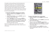
Current Sub Tab, To select the Current Station nearest to your location
 |
View all Garmin GPSMAP 292 manuals
Add to My Manuals
Save this manual to your list of manuals |
Page 49 highlights
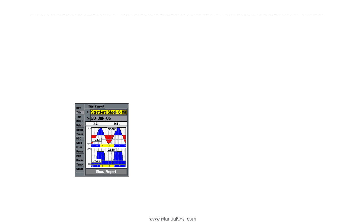
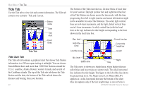
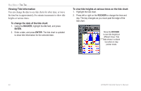
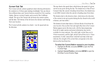
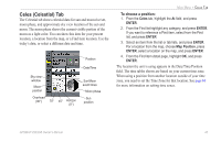
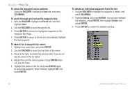
Current Sub Tab The Current sub tab contains graphical charts showing information for currents in a 24-hour span starting at midnight. You can choose from different dates and Current Stations around the USA coastline, Alaska, Hawaii, western Canada, and several of the Caribbean islands. The top of the Current sub tab shows the current station, and the date. The bottom of the tab shows the distance and bearing from your location. The Current sub tab contains two charts-one for speed and one for direction. MAIN MENU > TIDE TAB The top chart is the speed chart, which shows the speed of a given current at any point during the day. The shaded area is blue (Flood Current) when the current is heading toward shore; the shaded area is red (Ebb Current) when the current is heading away from shore. The bottom chart is the direction chart, which shows the direction of the current at any given point during the day (based on the north reference, not true north.) The bottom of each chart shows a 24-hour block of local time for your location. Day (yellow bar) and night (blue bar) at the Current Station appear across the time scale, with the time progressing from left to right (sunrise and sunset information may not be available for some stations). The solid, light vertical lines are in 4-hour increments, and the light, dotted vertical lines are in 1-hour increments. A solid, vertical line (with the local time at the top) indicates the strength of the current that corresponds to the time shown in the local time box. To select the Current Station nearest to your location: 1. Highlight the At field, and press ENTER to open the Find Currents Page. 2. Highlight Current Position, and press ENTER to open the Find Near Current Position Page. GPSMAP 292/298 Owner's Manual 43
-
 1
1 -
2
-
3
-
4
-
5
-
6
-
7
-
8
-
9
-
10
-
11
-
12
-
13
-
14
-
15
-
16
-
17
-
18
-
19
-
20
-
21
-
22
-
23
-
24
-
25
-
26
-
27
-
28
-
29
-
30
-
31
-
32
-
33
-
34
-
35
-
36
-
37
-
38
-
39
-
40
-
41
-
42
-
43
-
 44
44 -
 45
45 -
 46
46 -
 47
47 -
 48
48 -
 49
49 -
 50
50 -
 51
51 -
 52
52 -
 53
53 -
 54
54 -
55
-
56
-
57
-
58
-
59
-
60
-
61
-
62
-
63
-
64
-
65
-
66
-
67
-
68
-
69
-
70
-
71
-
72
-
73
-
74
-
75
-
76
-
77
-
78
-
79
-
80
-
81
-
82
-
83
-
84
-
85
-
86
-
87
-
88
-
89
-
90
-
91
-
92
-
93
-
94
-
95
-
96
-
97
-
98
-
99
-
100
-
101
-
102
-
103
-
104
-
105
-
106
-
107
-
108
-
109
-
110
-
111
-
112
-
113
-
114
-
115
-
116
-
117
-
118
-
119
-
120
 |
 |