Garmin GPSMAP 292 Owner's Manual - Page 74
Time Sub Tab, Comm Communications Sub Tab, Depth, Temperature, Pressure, Time Format, Time Zone
 |
View all Garmin GPSMAP 292 manuals
Add to My Manuals
Save this manual to your list of manuals |
Page 74 highlights
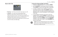
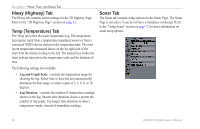
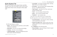
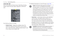
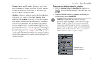
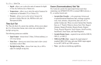
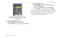
MAIN MENU > UNITS TAB • Depth-allows you to select the units of measure for depth in Feet (ft), Fathoms (fa) or Meters (m). • Temperature-allows you to select the units of measure for temperature in Fahrenheit (°F) or Celsius (°C). • Pressure-allows you to select units of measure for pressure in Inches Mercury (in), Millibars (mb), and Hectopascals (hPa). Time Sub Tab The Time tab shows the current time and date, allows you to adjust the 12 or 24 hour time format, enter a time zone, and adjust for daylight saving time. The following options are available: • Time Format-choose from 12 Hour, 24 Hour (military), or UTC time format. • Time Zone-choose your correct time zone to show correct local time or select Other. • Daylight Saving Time-choose from Auto, On, or Off to adjust for daylight saving time. Comm (Communications) Sub Tab The Comm tab controls the input/output format used when connecting your GPSMAP 292/298 to external NMEA devices, a PC, or another Garmin unit. • Garmin Data Transfer-is the proprietary format used to upload/download MapSource data, exchange waypoint, route, track, almanac, and proximity data with a PC or another Garmin unit. When you select Garmin Data Transfer, there are 11 Transfer Modes to choose from: Host, Request Almanac, Request Proximity, Request Routes, Request Tracks, Request Waypoints, Send Almanac, Send Proximity, Send Routes, Send Tracks, and Send Waypoints. • Garmin Remote Sonar-required for use with the GSD 20, GSD 21, or GSD 22. • NMEA In/NMEA Out-supports the input/output of standard NMEA 0183 data, and sonar NMEA input support for the DPT, MTW and VHW sentences. • None-provides no interfacing capabilities. 68 GPSMAP 292/298 Owner's Manual
-
 1
1 -
2
-
3
-
4
-
5
-
6
-
7
-
8
-
9
-
10
-
11
-
12
-
13
-
14
-
15
-
16
-
17
-
18
-
19
-
20
-
21
-
22
-
23
-
24
-
25
-
26
-
27
-
28
-
29
-
30
-
31
-
32
-
33
-
34
-
35
-
36
-
37
-
38
-
39
-
40
-
41
-
42
-
43
-
44
-
45
-
46
-
47
-
48
-
49
-
50
-
51
-
52
-
53
-
54
-
55
-
56
-
57
-
58
-
59
-
60
-
61
-
62
-
63
-
64
-
65
-
66
-
67
-
68
-
 69
69 -
 70
70 -
 71
71 -
 72
72 -
 73
73 -
 74
74 -
 75
75 -
 76
76 -
 77
77 -
 78
78 -
 79
79 -
80
-
81
-
82
-
83
-
84
-
85
-
86
-
87
-
88
-
89
-
90
-
91
-
92
-
93
-
94
-
95
-
96
-
97
-
98
-
99
-
100
-
101
-
102
-
103
-
104
-
105
-
106
-
107
-
108
-
109
-
110
-
111
-
112
-
113
-
114
-
115
-
116
-
117
-
118
-
119
-
120
 |
 |