Garmin aera 796 Pilot's Guide - Page 112
Terrain Views, Set Up Map, Terrain Shading, Main Menu, Terrain, Select Layout, Map with Profile
 |
View all Garmin aera 796 manuals
Add to My Manuals
Save this manual to your list of manuals |
Page 112 highlights
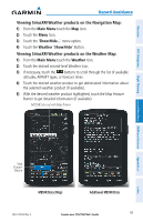
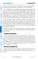
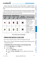
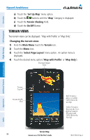
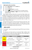
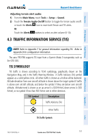
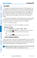
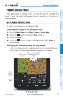
Overview GPS Navigation Hazard Avoidance a) Touch the 'Set Up Map' menu option. b) Touch the buttons until the 'Map' Category is displayed. c) Touch the Terrain Shading Field. d) Touch the On/Off Button. TERRAIN VIEWS Two terrain views can be displayed: 'Map with Profile' or 'Map Only'. Changing the terrain view: 1) From the Main Menu touch the Terrain Icon. 2) Touch the Menu Icon. 3) Touch the 'Select Page Layout' menu option. An option menu is displayed. 4) Touch the desired menu option ('Map with Profile' or 'Map Only'). Potential Impact Point Additional Features Hazard Avoidance Flight Planning Appendices Terrain Legend Terrain Profile View Terrain Map 98 Garmin aera 795/796 Pilot's Guide Red Terrain is above or within 100 ft below the aircraft. Yellow Terrain is Between the Userdefined Caution Elevation and 100 ft Below the Aircraft 190-01194-00 Rev. A Index
-
 1
1 -
2
-
3
-
4
-
5
-
6
-
7
-
8
-
9
-
10
-
11
-
12
-
13
-
14
-
15
-
16
-
17
-
18
-
19
-
20
-
21
-
22
-
23
-
24
-
25
-
26
-
27
-
28
-
29
-
30
-
31
-
32
-
33
-
34
-
35
-
36
-
37
-
38
-
39
-
40
-
41
-
42
-
43
-
44
-
45
-
46
-
47
-
48
-
49
-
50
-
51
-
52
-
53
-
54
-
55
-
56
-
57
-
58
-
59
-
60
-
61
-
62
-
63
-
64
-
65
-
66
-
67
-
68
-
69
-
70
-
71
-
72
-
73
-
74
-
75
-
76
-
77
-
78
-
79
-
80
-
81
-
82
-
83
-
84
-
85
-
86
-
87
-
88
-
89
-
90
-
91
-
92
-
93
-
94
-
95
-
96
-
97
-
98
-
99
-
100
-
101
-
102
-
103
-
104
-
105
-
106
-
 107
107 -
 108
108 -
 109
109 -
 110
110 -
 111
111 -
 112
112 -
 113
113 -
 114
114 -
 115
115 -
 116
116 -
 117
117 -
118
-
119
-
120
-
121
-
122
-
123
-
124
-
125
-
126
-
127
-
128
-
129
-
130
-
131
-
132
-
133
-
134
-
135
-
136
-
137
-
138
-
139
-
140
-
141
-
142
-
143
-
144
-
145
-
146
-
147
-
148
-
149
-
150
-
151
-
152
-
153
-
154
-
155
-
156
-
157
-
158
-
159
-
160
-
161
-
162
-
163
-
164
-
165
-
166
-
167
-
168
-
169
-
170
-
171
-
172
-
173
-
174
-
175
-
176
-
177
-
178
-
179
-
180
-
181
-
182
-
183
-
184
-
185
-
186
-
187
-
188
-
189
-
190
-
191
-
192
-
193
-
194
-
195
-
196
-
197
-
198
-
199
-
200
-
201
-
202
-
203
-
204
-
205
-
206
-
207
-
208
-
209
-
210
 |
 |