Garmin aera 796 Pilot's Guide - Page 151
Other Database Information, Tacan, And Vortac.
 |
View all Garmin aera 796 manuals
Add to My Manuals
Save this manual to your list of manuals |
Page 151 highlights
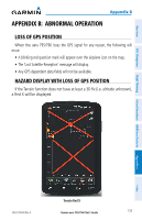
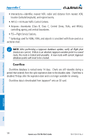
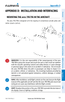
Worldwide Terrain Appendix C Overview GPS Navigation Flight Planning Hazard Avoidance Additional Features NOTE: The data contained in the terrain and obstacle databases comes from government agencies. Garmin accurately processes and cross-validates the data, but cannot guarantee the accuracy and completeness of the data. The terrain database is updated periodically and has no expiration date. Garmin Aviation Database Updates The Garmin aviation database updates can be downloaded directly to the unit by visiting the 'flyGarmin' website (fly.garmin.com). After the databases have been updated, check that the appropriate databases are initialized and displayed on the splash screen during power-up. OTHER DATABASE INFORMATION Jeppesen Navigation Database The aera 795/796 includes an internal Jeppesen® database that provides location and facility information for thousands of airports, VORs, NDBs, and more. Updates to the Jeppesen database are available every 28 days online (www.fly.garmin.com). The update program is designed to operate on Windows®-compatible PCs and requires the included USB cable to connect your aera 795/796 to the PC's USB port. The following information is provided from the internal Jeppesen database: • *Airport-identifier, facility name, city/state/country, latitude/longitude, field elevation, available fuel types, runway designations and layout, runway surface, runway length, runway width, runway lighting, communication frequencies, and published approaches. • Weather-frequencies associated with an airport (ASOS, ATIS, and AWOS). • *VORs-identifier, facility name, city/state/country, location (latitude/longitude), frequency, service volume (high, low, terminal), and type (such as VOR-DME, TACAN, and VORTAC). • *NDBs-identifier, facility name, city/state/country, location (latitude/longitude), and frequency. 190-01194-00 Rev. A Garmin aera 795/796 Pilot's Guide 137 Appendices Index
-
 1
1 -
2
-
3
-
4
-
5
-
6
-
7
-
8
-
9
-
10
-
11
-
12
-
13
-
14
-
15
-
16
-
17
-
18
-
19
-
20
-
21
-
22
-
23
-
24
-
25
-
26
-
27
-
28
-
29
-
30
-
31
-
32
-
33
-
34
-
35
-
36
-
37
-
38
-
39
-
40
-
41
-
42
-
43
-
44
-
45
-
46
-
47
-
48
-
49
-
50
-
51
-
52
-
53
-
54
-
55
-
56
-
57
-
58
-
59
-
60
-
61
-
62
-
63
-
64
-
65
-
66
-
67
-
68
-
69
-
70
-
71
-
72
-
73
-
74
-
75
-
76
-
77
-
78
-
79
-
80
-
81
-
82
-
83
-
84
-
85
-
86
-
87
-
88
-
89
-
90
-
91
-
92
-
93
-
94
-
95
-
96
-
97
-
98
-
99
-
100
-
101
-
102
-
103
-
104
-
105
-
106
-
107
-
108
-
109
-
110
-
111
-
112
-
113
-
114
-
115
-
116
-
117
-
118
-
119
-
120
-
121
-
122
-
123
-
124
-
125
-
126
-
127
-
128
-
129
-
130
-
131
-
132
-
133
-
134
-
135
-
136
-
137
-
138
-
139
-
140
-
141
-
142
-
143
-
144
-
145
-
 146
146 -
 147
147 -
 148
148 -
 149
149 -
 150
150 -
 151
151 -
 152
152 -
 153
153 -
 154
154 -
 155
155 -
 156
156 -
157
-
158
-
159
-
160
-
161
-
162
-
163
-
164
-
165
-
166
-
167
-
168
-
169
-
170
-
171
-
172
-
173
-
174
-
175
-
176
-
177
-
178
-
179
-
180
-
181
-
182
-
183
-
184
-
185
-
186
-
187
-
188
-
189
-
190
-
191
-
192
-
193
-
194
-
195
-
196
-
197
-
198
-
199
-
200
-
201
-
202
-
203
-
204
-
205
-
206
-
207
-
208
-
209
-
210
 |
 |