Garmin dezl OTR700 Owners Manual - Page 10
Viewing Recently Found Locations, Viewing Current Location Information, Saving Locations, Routes
 |
View all Garmin dezl OTR700 manuals
Add to My Manuals
Save this manual to your list of manuals |
Page 10 highlights
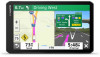
1 Select Where To?. 2 Search for a location. 3 From the location search results, select a location. 4 Select . A list of parking areas near the selected location appears. 5 Select Filter Parking, and select one or more categories to filter parking by availability, type, price, or payment methods (optional). NOTE: Detailed parking data is not available in all areas or for all parking locations. 6 Select a parking location. 7 Select Go!. Understanding Parking Colors and Symbols Parking locations that include detailed parking data are colorcoded to show the likelihood of finding parking. Symbols indicate the type of parking available (street or lot), relative pricing information, and payment type. You can view the legend for these colors and symbols on the device. From the parking search results, select . Viewing Recently Found Locations Your device stores a history of the last 50 locations you have found. Select Where To? > Recent. Clearing the List of Recently Found Locations Select Where To? > Recent > > Clear > Yes. Viewing Current Location Information You can use the Where Am I? page to view information about your current location. This feature is helpful if you need to tell emergency personnel your location. From the map, select the vehicle. Finding Emergency Services and Fuel You can use the Where Am I? page to find the nearest hospitals, police stations, and fuel stations. 1 From the map, select the vehicle. 2 Select Hospitals, Police Stations, Fuel, or Roadside Assist.. NOTE: Some service categories are not available in all areas. NOTE: When a truck vehicle profile is active, an option for truck stops appears instead of fuel. A list of locations for the selected service appears, with the nearest locations at the top. 3 Select a location. 4 Select an option: • To navigate to the location, select Go!. • To view the phone number and other location details, select . Getting Directions to Your Current Location If you need to tell another person how to get to your current location, your device can give you a list of directions. 1 From the map, select the vehicle. 2 Select > Directions to Me. 3 Select a starting location. 4 Select Select. Saving Locations Saving a Location 1 Search for a location (Finding a Location by Category, page 4). 2 From the search results, select a location. 3 Select > Save. 4 Enter a name, and select Done. Saving Your Current Location 1 From the map, select the vehicle icon. 2 Select Save. 3 Enter a name, and select Done. 4 Select OK. Editing a Saved Location 1 Select Where To? > Saved. 2 If necessary, select a category. 3 Select a location. 4 Select . 5 Select > Edit. 6 Select an option: • Select Name. • Select Phone Number. • Select Categories to assign categories to the saved location. • Select Change Map Symbol to change the symbol used to mark the saved location on a map. 7 Edit the information. 8 Select Done. Assigning Categories to a Saved Location You can add custom categories to organize your saved locations. NOTE: Categories appear in the saved locations menu after you have saved at least 12 locations. 1 Select Where To? > Saved. 2 Select a location. 3 Select . 4 Select > Edit > Categories. 5 Enter one or more category names, separated by commas. 6 If necessary, select a suggested category. 7 Select Done. Deleting a Saved Location NOTE: Deleted locations cannot be recovered. 1 Select Where To? > Saved. 2 Select > Delete Saved Places. 3 Select the box next to the saved locations to delete, and select Delete. Following a Route Routes A route is a path from your current location to one or more destinations. • The device calculates a recommended route to your destination based on the preferences you set, including the route calculation mode (Changing the Route Calculation Mode, page 8) and avoidances (Avoiding Delays, Tolls, and Areas, page 9). 6 Following a Route
-
 1
1 -
2
-
3
-
4
-
 5
5 -
 6
6 -
 7
7 -
 8
8 -
 9
9 -
 10
10 -
 11
11 -
 12
12 -
 13
13 -
 14
14 -
 15
15 -
16
-
17
-
18
-
19
-
20
-
21
-
22
-
23
-
24
-
25
-
26
-
27
-
28
-
29
-
30
 |
 |
