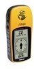
Garmin eTrex Owner's Manual - Page 43
Appendix B, What is GPS?
 |
UPC - 753759046019
View all Garmin eTrex manuals
Add to My Manuals
Save this manual to your list of manuals |
Page 43 highlights
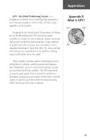
Appendices GPS - the Global Positioning System - is a navigation revolution. It's a technology that pinpoints a user's location anywhere in the world, 24 hours a day, regardless of the weather. Designed by the United States' Department of Defense for use by the military, the GPS System was made available to civilians for use in aviation, marine surveying and general outdoor/recreation markets. Today, millions of people utilize the accuracy and convenience of this amazing technology to hunt, fish, hike, fly, cruise and sail. GPS consists of a constellation of 24 satellites orbiting some 12,000 miles above the earth. These satellites transmit signals containing time and orbital data to calculate satellite position and almanac data. Meanwhile, receivers used on the ground, sea and air search the sky for the satellites. The GPS unit needs to acquire good signals from at least three satellites to determine a position on the surface of the earth. A fourth signal is required to get three-dimensional positioning which determines elevation or altitude. Appendix B What is GPS? 41
-
 1
1 -
2
-
3
-
4
-
5
-
6
-
7
-
8
-
9
-
10
-
11
-
12
-
13
-
14
-
15
-
16
-
17
-
18
-
19
-
20
-
21
-
22
-
23
-
24
-
25
-
26
-
27
-
28
-
29
-
30
-
31
-
32
-
33
-
34
-
35
-
36
-
37
-
 38
38 -
 39
39 -
 40
40 -
 41
41 -
 42
42 -
 43
43 -
 44
44 -
 45
45 -
 46
46 -
 47
47 -
 48
48 -
49
-
50
-
51
-
52
-
53
-
54
-
55
-
56
 |
 |
