2011 Ford Edge MyFord Touch/MyLincoln Touch Supplement 3rd Printing - Page 68
2011 Ford Edge Manual

Page 68 highlights
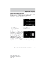
Navigation features • Starting point: This icon indicates the starting point of a planned navigation route. • Waypoints: This icon indicates the location of a waypoint on the map. The number inside the circle is different for each waypoint and represents the position of the waypoint in the route list. • Destination symbol: This icon indicates the location of the final destination on the map. • Next maneuver point: This icon shows the location where the next turn should occur on the planned route. • No GPS symbol: This icon indicates that insufficient GPS satellite signals are being received for accurate map positioning. The symbol may be intermittently displayed under normal operation in an area with poor GPS access. Quick touch buttons When in map mode, touch anywhere on the map display to access the following options: • Set as Dest: Press to select a scrolled location on the map as your destination. (You may scroll the map by pressing your index finger on the map display. When you reach the desired location, simply let go and then press 'Set as Dest'. • Set as Waypoint: Press to set the current location as a waypoint. • Save to Favorites Press to save the current location to your favorites. • POI Icons On/Off: Press to select POI icons to be displayed on the map. Up to three icons can be selected for display on the map at the same time. 68 See End User License Agreement at the end of this book 2011 HMI-1 Gen 2 (fd1) Supplement, 3rd Printing USA (fus)
-
 1
1 -
2
-
3
-
4
-
5
-
6
-
7
-
8
-
9
-
10
-
11
-
12
-
13
-
14
-
15
-
16
-
17
-
18
-
19
-
20
-
21
-
22
-
23
-
24
-
25
-
26
-
27
-
28
-
29
-
30
-
31
-
32
-
33
-
34
-
35
-
36
-
37
-
38
-
39
-
40
-
41
-
42
-
43
-
44
-
45
-
46
-
47
-
48
-
49
-
50
-
51
-
52
-
53
-
54
-
55
-
56
-
57
-
58
-
59
-
60
-
61
-
62
-
 63
63 -
 64
64 -
 65
65 -
 66
66 -
 67
67 -
 68
68 -
 69
69 -
 70
70 -
 71
71 -
 72
72 -
 73
73 -
74
-
75
-
76
-
77
-
78
-
79
-
80
-
81
-
82
-
83
-
84
-
85
-
86
-
87
-
88
-
89
-
90
-
91
-
92
 |
 |
